Tusla
| Tusla Тузла Коса |
||
|---|---|---|
| Tusla Island in front of the bridge | ||
| Waters | Strait of Kerch | |
| Geographical location | 45 ° 16 ′ 6 ″ N , 36 ° 33 ′ 0 ″ E | |
|
|
||
| length | 6.7 km | |
| width | 700 m | |
| surface | 3.5 km² | |
| Highest elevation | 1 m | |
| Residents | 50 14 inhabitants / km² |
|
|
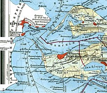
The Kerch Strait with the island of Tusla - the island in the middle (the lower island) - stretches very narrowly from northwest to southeast |
||
Tusla ( Ukrainian and Russian Тузла Коса ; Crimean Tatar Tuzla ) is the name of an approximately 200 to 500 m wide and 6 km long island in the Kerch Strait , between the Crimean Peninsula and the Taman Peninsula . The Crimean Bridge crosses the island .
In the course of the dissolution of the Soviet Union in 1991, the Ukrainian Soviet Socialist Republic became an independent Ukrainian state on August 24, 1991 within the existing borders, including Crimea and Tuzla. From 1992 there were already Russian attempts to secede and quarrels over the Autonomous Republic of Crimea . Since April 2014 the entire Crimean peninsula and thus also the island of Tusla has been claimed, controlled and administered by Russia . Most states do not recognize this under international law.
history
Even before the 20th century, what was then the Kossa Tusla peninsula ( e.g. Spit Tusla ) was of economic and strategic importance. The surrounding waters were very rich in fish. In addition, the spit formed a natural border between the Azov and Black Seas . The strait was controlled by the Kerch fortress ( Ukrainian Фортеця Керч, Форт Тотлебен ). In order to narrow the passage to the firing range of the cannons possible at that time (approx. 3 km), the strait was limited by a stone dam that protrudes about 1200 m northwest of the cape into the Kerch Strait.
The island was only separated from the Taman Peninsula by erosion in the 1920s , which it extended as a spit to the northwest. In 1941 the Supreme Soviet of the RSFSR transferred the administration of the island from the Krasnodar region to Crimea, which was also Russian at the time . In 1954, Crimea was transferred from the Presidium of the Supreme Soviet to the Ukrainian SSR, but the island of Tusla was more or less overlooked, as it was a restricted military area at that time and was therefore administered directly by the RSFSR. In 1973 the administrations of Crimea and the Krasnodar Territory jointly decided that the island should be administered by the Crimea. However, there has not yet been an international treaty or any other formal regulation between Ukraine and Russia.
The island has great strategic value for both Russia and Ukraine, as it lies on the eastern side of the strait opposite Crimea. If Ukraine had control of the island, it would have been able to control the fairway of the strait between the Azov and the Black Seas and charge fees to passing ships. In addition, the demarcation of the sea between the two states indirectly depends on the ownership of the island. Since larger natural gas deposits are suspected under the Kerch Strait , this is also of economic importance.
The conflict over the island has simmered since the dissolution of the Soviet Union. It became acute in 2003 when Russia began building a road embankment from its territory ( Taman Peninsula ) to the island against the stated will of the Ukrainian government . The Ukraine then strengthened its border post militarily and had the strait between the island and the Russian mainland deepened with a dredger .
In December 2010 the Ukrainian Ministry of Foreign Affairs announced the demarcation of the exact border line for the following year. The first meeting of the Russian-Ukrainian Demarcation Commission took place on December 20, 2010 in Moscow. After lengthy negotiations, the presidents of Ukraine and Russia were supposed to sign an agreement at a meeting in Yalta on July 12, 2012, according to which the island of Tusla and the fairway of the strait between the Azovshem and Black Sea would remain under Ukrainian sovereignty, but the waterway would be managed jointly should. The course of the maritime border should be determined in such a way that both states are able to jointly use assumed raw material deposits.
With the annexation of Crimea by the Russian Federation , the island came under Russian control in March 2014, which is why a direct transport connection from Russian territory to Crimea was given the highest priority and a bridge that spans the length of the island was immediately planned and in May 2018 was officially opened.
About 20 families lived on the island who lived from fishing and some rest homes, and there were also some holiday homes there. As part of the construction work, the space was claimed by the construction site.
In April 2018, the FSB (to which the Russian border control is subject) began to stop ships trying to call at Ukrainian ports on the Sea of Azov.
Web links
- The dam of contention: The conflict over the island of Tusla , November 6, 2003, Konrad-Adenauer-Stiftung
Individual evidence
- ↑ Archived copy ( memento of February 10, 2011 in the Internet Archive ) (no longer available)
- ↑ Отношения перешли в русло ( Eng . Relationships normalize ). In: Kommersant , July 11, 2012.
- ↑ NZZ.ch July 12, 2018: Russia wears down Ukraine from the sea


