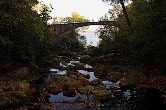
Twannbach
|
Twannbach La Douanne |
||
|
Bach with the Twannbach Bridge |
||
| Data | ||
| Water code | CH : 3201 | |
| location |
law
|
|
| River system | Rhine | |
| Drain over | Aare → Rhine → North Sea | |
| source | north of Châtillon 47 ° 6 ′ 7 ″ N , 7 ° 5 ′ 58 ″ E |
|
| Source height | 805 m above sea level M. | |
| muzzle | at Kleintwann in the Bielersee Coordinates: 47 ° 5 '30 " N , 7 ° 9' 14" E ; CH1903: 578 384 / 215 654 47 ° 5 '30 " N , 7 ° 9' 14" O |
|
| Mouth height | 429 m above sea level M. | |
| Height difference | 376 m | |
| Bottom slope | 63 ‰ | |
| length | 6 km | |
| Catchment area | 18.8 km² | |
| Discharge A Eo : 18.8 km² at the mouth |
MQ Mq |
620 l / s 33 l / (s km²) |
The Twannbach , also called La Douanne , is a 6 kilometer long stream in the Bernese Jura .
geography
course
The Twannbach rises on the Montagne de Diesse , north of the hamlet of Châtillon belonging to the Plateau de Diesse , at an altitude of about 806 m. It flows first in a northeasterly direction. At Sur les Moulins, a hamlet of Plateau de Diesse, he makes an arc and turns his direction south. It digs its way through the narrow Twannbach Gorge and finally flows into Lake Biel at Twann , in the Kleintwann district.
Tributaries
- Ruisseau les Moulins ( left )
Web links
Commons : Twannbach - Collection of images, videos and audio files
- Map of the Twannbach (PDF file; 594 kB)
Individual evidence
- ↑ a b water network in WebGis geographic information system of Berne
- ↑ a b Geoserver of the Swiss Federal Administration ( information )
- ↑ Modeled mean annual discharge. In: Topographical catchment areas of Swiss waters: area outlets. Retrieved November 3, 2015 .
