Tweed Shire
| Shire of Tweed | |
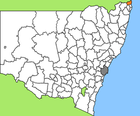
 Location of the Tweed Shire in New South Wales |
|
| structure | |
| State : |
|
| State : |
|
| Administrative headquarters: | Murwillumbah |
| Dates and numbers | |
| Area : | 1,307.7 km² |
| Residents : | 91,371 (2016) |
| Population density : | 70 inhabitants per km² |
Coordinates: 28 ° 20 ′ S , 153 ° 24 ′ E Tweed Shire is a local government area (LGA) in the Australian state of New South Wales . The area is 1,307.7 km² and has about 91,000 inhabitants.
Tweed is located in the far northeast of the state on the Pacific coast and the border with Queensland about 130 km southeast of the metropolis of Brisbane and 820 km northeast of Sydney . The area includes 120 hamlets and villages, including Banora Point, Bogangar, Burringbar, Chillingham, Condong, Eungella, Fingal Head, Hastings Point, Kunghur, Mooball, Murwillumbah, Pottsville Beach, Tumbulgum, Tweed Heads , Tyalgum, Uki, and parts of Bilambil , Kingscliff and Terranora. The headquarters of the Shire Council is in the city of Murwillumbah in the center of the LGA, where about 9,200 residents live.
Special
RTL's jungle camp is located on an old farm northwest of Murwillumbah . The area on a farm was converted into a jungle backdrop and the animals were brought there specially. The location, which is only 30 km from Queensland's Gold Coast , also served as the location for the English original of the reality show.
administration
By May 2005, the Tweed Shire Council had eleven members elected by LGA residents. Tweed is not divided into districts. The mayor of the council was also recruited from among the councilors.
Because of allegations of corruption, the state government dissolved the council in 2005 and appointed two administrators and a five-person senior management team to run the business until the next elections in September 2008.
Web links
Individual evidence
- ↑ a b Australian Bureau of Statistics : Tweed (A) ( English ) In: 2016 Census QuickStats . June 27, 2017. Retrieved May 12, 2020.
- ^ Australian Bureau of Statistics : Murwillumbah ( English ) In: 2016 Census QuickStats . June 27, 2017. Retrieved May 12, 2020.