
Tysfjord (inlet)
| Tysfjord Divtasvuodna |
||
|---|---|---|
| Waters | European Arctic Ocean | |
| Land mass | Scandinavian peninsula | |
| Geographical location | 68 ° 10 ' N , 16 ° 13' E | |
|
||
| length | With Hellmofjord 59 km | |
| Greatest water depth | 897 m | |


The Tysfjord ( Norwegian Tysfjorden , Lule Divtasvuodna ) is an inlet between the northern Norwegian communities Narvik and Hamarøy in Nordland which extends from the inner part of the Vestfjords extends to the south. The fjord is 59 km (32 nm) long (from Korsnes to Hellmobotn) and 897 m deep at Hulløya.
Its main branches are Beisfjord , Fuglfjord , Grunnfjord , Hellmofjord , Indre Tysfjord , Mannfjord , Stefjord and Tømmeråsfjord . The Norwegian name is derived from the Sami word divtas . The second part of the word vuodna means "fjord".
The fjord gave its name to the municipality of Tysfjord , which was founded on January 1, 1869 and dissolved on January 1, 2020 .
geography
The Tysfjord has its mouth south of the island of Barøya and north of Korsnes . It is the easternmost branch of the Vestfjord . The Bremneset peninsula lies at the transition between the Vestfjord and the Ofotfjord .
The length of the fjord can be defined in two different ways:
- The longest length is 59 km from Bremneset to the hamlet of Hellmobotn at the end of the Hellmofjord .
- The Tysfjord without fjord arms is only 29 km long from Bremneset to Hellandskjånes.
Arms of the fjord
The Tysfjord has eight branches. From the northeast:
- Stefjord (16 km long)
- Tømmeråsfjord (5 km)
- Fuglfjord (4.5 km). This branches off at the widest part of the Tysfjord and is also called Haukøyfjord .
Follow further on the east side:
- Indre Tysfjord (17 km)
- Mannfjord (12.8 km)
- Grunnfjord (15 km).
On the west side:
- Beisfjord (4.5 km).
To the south, as an extension of the Tysfjord:
- Hellmofjorden (31 km). This is even two kilometers longer than the main fjord.
Skrovkjosen is a large and striking bay that branches off from Hellmofjord eight kilometers east of the confluence with the Tysfjord.
Islands
Hulløya between Kjøpsviksund and Hulløysund is the largest island in the Tysfjord with an area of 22 km². To the southwest of it is the much smaller island Litl-Hulløya (approx. 0.8 km²). Haukøyholmen with about 1.3 km² is the largest island in the Haukøyfjord. The island of Bekkenesholmen with a nature reserve in Skrovkjosen is about 0.4 km².


Surroundings
The area on the west side of the Tysfjord consists of relatively little forested mountains and hills, with a number of lakes between the Beisfjorden and Drag. At 521 m, Bogvetten is the highest point north of Storjord. South of Hellandsberg, at Hellmofjord, the landscape changes almost immediately into a coherent fell area, which extends around almost the entire rest of the fjord system to Valletendan near Bremneset outside the Ofotfjord. Most of the peaks there reach over 700 m, some even over 1000 m.
There are scattered clusters of houses in some isolated valleys rising up from the fjord coast. For example Hellmobotn and Mannfjordbotn have approximately 2 km² of flat land before the climb into the mountains begins. Kjøpsvik is located near Kjøpsnes, wedged between the fjord and the 849 m high Lifjell . Stetind (1391 m), Norway's nationalfjell on the Stefjord is the highest mountain in the area of the Tysfjord. The establishment of a nature reserve has been proposed for the largely untouched fjell and fjord area in the inner part and further east towards Sweden. This is said to extend from Sørfold in the south to Ballangen in the north.
colonization
With the exception of a few smaller hamlets, the entire population of the former municipality of Tysfjord , a total of almost 2000 people, is located around the fjord. The Kjøpsvik Community Center is on the east side. The drag scene and the smaller town of Storjord on the Beisfjord act as local centers for the west side of the fjord, especially for Hellandsberg south of Drag and Korsnes north of Storjord. Storå is located south of Kjøpsvik . Musken , in the middle of Hellmofjord, is the only place in Norway with a purely Lule Sami population. Hellmobotn , Grunnfjordbotn , Mannfjorden and some farms and hamlets along the fjord arms are now depopulated.
traffic
.jpg)
.png)
Average traffic volume , counted in weighted vehicle units per day 2000–2010
(TorbjørnS - source: Vegvesenet )
- Three important ferry connections cross the Tysfjord or have a starting point at it:
- E6 in the north between Bognes on the west and Skarberget on the east.
- Rv827 in the south between Drag on the west side and Kjøpsvik on the east side.
- The connection between Bognes and Lødingen via the Vestfjord is an important link between the European routes E6 and E10 .
- A speedboat connects some pathless hamlets by the Tysfjord and its fjord arms ( Nevervika , Storå og Hulløya ) with Kjøpsvik and Drag.
- The regional road 681 ( Fylkesvei ) leads 5 km north from the E 6 to Korsnes .
- The regional road 682 (Fylkesvei) leads from the E 6 5 km south from Drag to Hellandsberg .
- The regional road 683 (Fylkesvei) leads from the E 6 5 km to the east along the Beisfjord.
- A municipal road runs south from regional road 683 to Nevervika.
- Regional road 684 (Fylkesvei) runs 8 km north from Kjøpsvik to Hundholmen and Kjelkvika.
- The roads between the E 6 and Eidet on the east side of Skrovkjosen and between the N 827 and Haukøya along the Tømmeråsfjord.
- The roads between Storå and Tørrnes and between Tjårrnes and Råna that are not connected to other roads.
history
- In order to make the road to Korsnes passable, the ferry connection to Skarberget was opened in 1941. In 1942 the ferry dock was moved to Bognes.
- The ferry between Drag and Kjøpsvik opened in 1968 and joined the triangular connection in 1992, which also included Skarberget.
Polar orbit
During the German occupation in World War II , alternatives for the alignment of the polar orbit in the direction of Narvik were examined: A train ferry between Korsnes and Skarberget or a spiral tunnel at Hellmobotn, which would have enabled a ferry-free connection.
Ferry-free E6
In terms of traffic, the Tysfjord divides Norway into two parts. The ferry connection between Bognes and Skarberget is the only remaining ferry on the E6. The only ferry-free diversion options are through Sweden. The following solutions have been proposed:
In the last survey carried out for the area, five possible concepts were examined, including a 13 km long submarine tunnel or a 3 km bridge connection between the areas around Bognes and Skarberget. A new road route leading south to Drag and connecting the N827 with four bridges was also proposed. The investigation was handed over to the Norwegian Ministry of Transport in 2012 , with recommendations from the Statens vegvesen to maintain, improve and, if possible, shorten the current E6 connection, while the N827 connection can be weakened in order to maintain a more local function with reallocation to a regional road connection. The time horizon for this investigation is until 2040, which means that the desire for a ferry-free E6 will probably not be realized in the near future.
tourism
- Whale , sea eagle and aurora safaris .
- Diving .
- Caving in the deepest cave in Northern Europe, Råggejávrrerájgge .
- Hellmobotn is a popular starting point for cross-country skiers, with marked trails that lead to Sweden, among other places.
- The Grenseleden ( Swedish: Gränsleden ) hiking trail with its starting point at Sørfjord is a marked hiking trail that was previously used as a trade route and as an escape route to Sweden during World War II.

Killer whales (orcas) in the Tysfjord

Two orcas in the Tysfjord
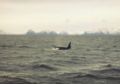
Orca in the Tysfjord at dusk

View from the north


Individual evidence
- ↑ Directorate for natural foresting. Retrieved January 13, 2013 (Norwegian).
- ↑ Harald Bjerkeli: Polar Banen. Retrieved January 13, 2013 (Norwegian).
- ↑ Vil beholde dagens trasé and ha ferger døgnet rundt. Statens vegvesen, January 31, 2012, accessed January 13, 2013 (Norwegian).
- ↑ Vil beholde ferge… In: Lokalavisa Nord-Salten. February 2, 2012, accessed January 13, 2013 (Norwegian).
- ↑ Grenseleden. Tysfjord Kommune, accessed January 13, 2013 (Norwegian).
Web links
- Torghatten North. Retrieved January 15, 2013 (Norwegian, ferries and speedboats in Tysfjord).
- Tysfjord commun. Retrieved January 15, 2013 (parish website).
- Orca Tysfjord. Retrieved January 15, 2013 (Norwegian, orca safaris).
- Orca Tysfjord. Retrieved January 15, 2013 (orca safaris).
- Arctic Encounters. Retrieved January 15, 2013 (Norwegian, diving and other activities).
- Liddno. Retrieved January 15, 2013 (Norwegian, caving).