
Ulica Jana III Sobieskiego
| Ulica Jana III Sobieskiego | |
|---|---|
|
|
|
 |
|
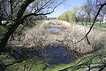
| The Sobieskiego towards the city center | |
| Basic data | |
| place | Warsaw |
| District | Mokotów / Wilanów |
| Hist. Names |
Droga Królewska , Aleja Sobieskiego |
| Connecting roads |
Ulica Belwederska , Aleja Wilanowska |
| Cross streets | 11 on the east side, 9 on the west side |
| use | |
| User groups | Pedestrian traffic , bicycle traffic , individual traffic , public transport |
| Technical specifications | |
| Street length | about 4,000 meters |
The Ulica Jana III Sobieskiego is a major north-south thoroughfares of Warsaw and is located on the left side, west side of the Vistula . It connects Ulica Belwederska with Aleja Wilanowska and is thus part of the Warsaw Royal Wing . According to King Jan III. Sobieski named Sobieskiego runs bend-free for about four kilometers and cuts through the districts of Mokotów (with the districts Sielce, Stegny and Sadyba) and Wilanów (district Wilanów Stary). It has had its current name since 1919, before the route was calledDroga Królewska called. From 1972 to 1975 it was widened.
Course and construction objects
The Sobieskiego runs continuously in three lanes, whereby in the northern part the use of the right lane at certain times is reserved for local public transport and taxis. Up until the war the sides of the street were largely undeveloped, and in some cases this is still the case today. The fort Chee of the Warsaw fortifications, which is still in existence today, extended west of the road for about half of the route . From 1930 onwards, large allotment gardens were laid out on the former esplanade of the fortifications - on the throat side of the fort. These also still exist today. Some open spaces were used for block development after the war - a large complex of this kind east of the street is the “Sadyba” settlement. The “Park Sielecki” (German: Sielce-Park ), also known as “Lasek Sielecki” (German: Sielce-Wäldchen ), which was popular before the war , no longer exists.
East side of the road (north to south)
- Chełmska Street
- Sobieskiego 114 - a block of flats built in 1962/63 based on a design by Zygmunt Lewański and W. Witkowski. He won the "Mister '63" award in the competition for the best new building in Warsaw
- Sobieskiego 104/110 - Elongated office and residential complex built in the late 1990s. Here, along with other companies, is the headquarters of the Polish Medical Association founded in 1922 (Polish: Naczelna Izba Lekarska )
- Władysława Hańczy Street
- Ulica Ludwika van Beethovena
- Crossing with Ulica Ludwika Idzikowskiego
- The Bernardiner Graben (Polish: Bernardyńska Woda) runs between Sobieskiego and Ulica Powsińska . The moat originally belonged to the fortifications of the 19th century, an artificial, roughly triangular catch basin is still located between the Sobieskiego , the Idzikowskiego and the Witosa . In 1891 the engineers Henryk Huss and Wiktor Magnus built the line for the narrow-gauge railway line Warsaw-Piaseczno , which ran from Warsaw via Powsin to Piaseczno . The last parts of the line were dismantled in the 1960s
- Aleja Wincentego Witosa
- Bolesława Limanowskiego Street
- Sobieskiego 72 - the diplomat Witold Jurasz lived in this building
- Sobieskiego 68 - school building. Located in the “Sadyba” housing estate, this school was built in 1970/71 according to a design by Halina Skibniewska , Andrzej Malek, Tadeusz Perszyński and W. Bryndza-Nacki. It was awarded the title "Mister '71" in the competition for the best building in Warsaw in 1971
- Crossing with Ulica Świętego Bonifacego
- Oręzna Street
- Truskawiecka Street
- Nałęczowska Street
- Goplańska Street

Start of the street in the north (corner of Chełmska)

New office building with the seat of the medical association
The Bernardyńska Woda Canal
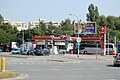
Orlen petrol station on Limanowskiego

End of Sobieskiego in the south


West side of the road (north to south)
- Ulica Dolna
- Franciszka Kostrzewskiego Street
- Allotment gardens in the former rear area of the Piłsudski Fort
- Crossing with Ulica Ludwika Idzikowskiego
- Fort Piłsudskiego, which is about 150 meters west of Sobieskiego before the intersection with Ulica Generała Władysława Sikorskiego ; in between there is an RWE Polska power distribution station
- Aleja Generała Władysława Sikorskiego
- Start hotels “Portos” ( Best Western ), “Atos” and “Aramis” of the Puhit group
- Mangalia Street
- Czarnomorska Street
- Crossing with Ulica Świętego Bonifacego
- Śródziemnomorska Street
- Sobieskiego 15 - Church of St. Antonio Maria Zaccaria (Polish: Kościół św. Antoniego Marii Zaccarii )
- Sobieskiego 9 - Psychiatric and Neurological Institute (Polish: Instytut Psychiatrii i Neurologii), here is also the Polish Psychiatric Society (Polish: Polskie Towarzystwo Psychiatryczne )
- Sobieskiego 1 - Modern luxury apartment house
- Aleja Wilanowska and the first section of the Aleja Rzeczypospolitej built from 2010 to 2011 , which is to run through the new Miasteczko Wilanów area to the west (Powsin)

Allotments on the west side of the street

Distribution plant of RWE Stoen

Office building complex at the Sikorskiego intersection

Hotel group Puhit

Church building on the Św. Bonifacego

Psychiatric clinic


References and comments
- ↑ according to Information The Polish Chamber of Physicians and Dentists ( Memento of the original from December 26, 2008 in the Internet Archive ) Info: The archive link was automatically inserted and has not yet been checked. Please check the original and archive link according to the instructions and then remove this notice. on the association's website (in English, accessed on September 16, 2011)
- ^ Witold Jurasz (1931-2004) was a Polish diplomat. He was his country's ambassador to Venezuela , Nigeria , Iraq and Kuwait and Libya
- ↑ according to Information Historia parafii on the municipality's website (in Polish, accessed September 16, 2011)
literature
- Julius A. Chroscicki and Andrzej Rottermund: Architectural Atlas of Warsaw. 1st edition, Arkady, Warsaw 1978, p. 204
Web links

Structure of the approximately 10 km long Warsaw Royal Route (Polish: Trakt Królewski ) from north (city center) to south (Wilanów)
Coordinates: 52 ° 23 '22.6 " N , 20 ° 55' 35.2" E