
Aleja Wilanowska
| Aleja Wilanowska | |
|---|---|
|
|
|
 |
|
| The Wilanowska at the level of the cemetery Wilanow (wall right) towards the city center | |
| Basic data | |
| place | Warsaw |
| District | Mokotów / Wilanów |
| Connecting roads | Marynarska Street |
| Cross streets | 12 on the north side, 30 on the south side - some only with pedestrian access |
| use | |
| User groups | Pedestrian traffic , bicycle traffic , individual traffic , public transport |
| Technical specifications | |
| Street length | about 5,800 meters |
The Aleja Wilanowska is an important Warsaw street thoroughfare passing through the west of the Vistula lying neighborhoods Mokotów and Wilanów leads. Its length is around 5,800 meters, on its last section (in Wilanów) it is the approximately 1,000 meters long end piece of the historic Warsaw Royal Wing .
Originally there was only a dirt road connecting Wilanów with the village of Służewiec (now part of Mokotów). Around 1775 this path was straightened, expanded and extended to today's Ulica Puławska . It was later extended to the crossing Ulica Wołoska . Until 1941, the section of road in Wilanów was known as Aleja Królewska . In 2009 and 2010, the road between Ulica Dolina Służewiecka / Aleja Generała Władysława Sikorskiego and Ulica Jana III Sobieskiego was expanded to include two lanes each. The Wilanowska is used by public transport buses on its entire route . It has two lanes throughout in every direction of travel.
Course and construction objects
The Wilanowska begins in the west as an extension of the Ulica Marynarska at the intersection with the Wołoska , and then leads approximately eastwards first through the district of Mokotów, crossing the Aleja Niepodległości , which merges here with the Ulica Puławska , leads at the level of the Dominican, built in 1936 -Cloister of St. Joseph down the Vistula embankment and from there straight on to the castle in Wilanów . In the second part, it crosses the heavily traveled, three-lane Dolina Służewiecka / Generała Władysława Sikorskiego at the foot of the Vistula embankment and connects - already in the Wilanów district - with Ulica Jana III Sobieskiego . Since 2010 there has been a crossing at this point due to the new construction of Aleja Rzeczypospolitej . With the Sobieskiego the historical Königsweg flows into the Belwederska .
Some of the smaller side streets (more like paths) have lost their vehicle connection to Wilanowska after street modernization and the renewal of the moats on the edge of Miasteczko Wilanów .
North side of the street (west to east)
- Wołoska Street
- Galeria Mokotów shopping center
- Rodziny Hiszpańskich Street
- Crossing with Ulica Zygmunta Modzelewskiego
- Crossing with Aleja Niepodległości
- Crossing with Ulica Puławska
- Metro station A 7 "Wilanowska"
- Ulica Grabowa
- Bukowińska Street
- Aleja Wilanowska 204 - the former Żółta Karczma inn , now the seat of the Museum of the History of the Polish Peasant Movement
- Potoki Street
- Ulica Lubaszki
- Aleja called Władysława Sikorskiego
- Back of the Psychiatric and Neurological Institute (Polish: Instytut Psychiatrii i Neurologii ), here is also the Polish Psychiatric Society (Polish: Polskie Towarzystwo Psychiatryczne )
- Ulica Jana III Sobieskiego
- Kosiarzy Street
- Cemetery in Wilanów, which Stanisław Kostka Potocki had laid out in 1816 on a circular plan. In 1860 it was extended to a design by Henryk Marconi and again in 1877. The standing here neo-Gothic cemetery chapel was built between 1823-1826, designed by Chrystian Piotr Aigner on behalf of Aleksandra Potocka built
- Intersection with Ulica Przyczółkowa , the Wilanow south with Powsin and Konstancin-Jeziorna links

Galeria Mokotów
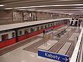
Metro station "Wilanowska"

"Żółta Karczma", a former inn
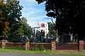
Wilanów cemetery with the Aigner chapel


South side of the street (west to east)
- Ulica Wincentego Rzymowskiego
- Aleja Lotników
- Crossing with Ulica Zygmunta Modzelewskiego
- Ulica Wita Stwosza
- Crossing with Aleja Niepodległości
- Crossing with Ulica Puławska
- Michała Wołodyjowskiego Street
- Ulica Jana Skrzetuskiego
- Ulica Wernyhory
- Ulica Rolna
- Wilanowska 313a - Consular Section of the Embassy of Sri Lanka
- Ulica L. Podbipięty
- Karola Kurpińskiego Street
- Studencka Street
- Wróbla Street
- Dominikańska Street
- Aleja Wilanowska 257 - finished in 2011 Alzheimer -Zentrum
- Ulica Łukowa
- Ulica Dolina Służewiecka
- Ulica Fosa
- Blacksmith Museum in Warsaw
- Ulica Karczocha
- Szpinakowa Street
- Sałatkowa Street
- Rabarbarowa Street
- Pomidorowa Street
- Ulica Aleksandra Patkowskiego
- Arbuzowa Street
- Aleja Rzeczypospolitej
- New residential area Miasteczko Wilanów
- Sarmacka Street
- Ulica Rycerstwa Polskiego
- Ulica Krzysztofa Kieślowskiego
- Monument of Johann III. Sobieski and his wife Maria Kazimiera Sobieska
- Crossing with Ulica Przyczółkowa
- "Pod Karabelą" restaurant

Alzheimer's Center

Blacksmith Museum in Służewiec

The confluence of the Sobieskiego with the Wilanowska

Monument to the Sobieski couple


References and comments
- ↑ Klasztor św. Józefa, Ojcowie Dominikanie , gem. Monastery website (in Polish, accessed September 26, 2011)
- ↑ Dom Pomocy Społecznej, Centrum Alzheimera , gem. Institution website (in Polish, accessed September 26, 2011)
literature
- Julius A. Chroscicki and Andrzej Rottermund: Architectural Atlas of Warsaw. 1st edition, Arkady, Warsaw 1978, p. 220
Web links
- Aleja Wilanowska in Warszawa-Wikia

Structure of the approximately 10 km long Warsaw Royal Route (Polish: Trakt Królewski ) from north (city center) to south (Wilanów)
Coordinates: 52 ° 10 ′ 30.1 ″ N , 21 ° 2 ′ 40 ″ E