Mbuluzi
|
Mbuluzi iMbuluzi, Umbeluzi |
||
|
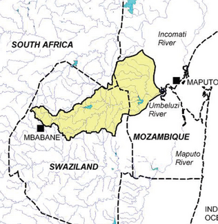
Catchment area of the Mbuluzi River in the north of Eswatini , south of Mozambique and (marginally) east of South Africa |
||
| Data | ||
| location |
|
|
| River system | Mbuluzi | |
| Drain over | Espírito Santo Estuary → Indian Ocean | |
| Source height | 1030 m | |
| muzzle |
Maputo Bay , Mozambique Coordinates: 26 ° 0 ′ 16 ″ S , 32 ° 28 ′ 48 ″ E, 26 ° 0 ′ 16 ″ S , 32 ° 28 ′ 48 ″ E |
|
| Mouth height | 0 m | |
| Height difference | 1030 m
|
|
| Catchment area | 5040 km² | |
| Discharge at the gauge Inflow Pequenos-Libombos reservoir A Eo : 3735 km² |
MNQ 2004–2013 MQ 2004–2013 Mq 2004–2013 MHQ 2004–2013 |
3.7 m³ / s 8 m³ / s 2.1 l / (s km²) 16.8 m³ / s |
| Left tributaries | Tsambokhulu | |
| Right tributaries | Mlaula River | |
| Reservoirs flowed through | Pequenos Libombos Reservoir | |
The Mbuluzi (also: iMbuluzi , Umbeluzi ) is one of the main rivers of Swaziland . It runs to the east, also crosses Mozambique and flows into the Indian Ocean in Maputo Bay .
geography
There are two main sources of the river, one in the highveld north of Mbabane in Graystone Eco Park . There the Black Mbuluzi rises and runs north for a short time before turning to the east and winding in a winding course to the east to the border of Manzini . It crosses the Hlane Royal National Park . From then on it serves as a border river for long stretches until it flows into the Mnjoli reservoir . In the Middleveld of Lubombo it first winds north and east before it merges with its southern source river, the iMbuluzane , at Tabankulu , near the sugar plantations of Mhlume .
The source of the White Mbuluzi (imbuluzane) is in the Middleveld near Manzini ( ⊙ at 770 m above sea level ). This tributary enters the Middleveld earlier , runs just as winding as its northern brother to the north-northeast and briefly forms the border between Manzini and Lubombo about 6 km south of the Mnjoli reservoir. Then it continues to the northeast to merge with the "Black Mbuluzi".
From then on, the river winds further east and east of Tabankulu takes on the Tsambokhulu, which flows in from the left and north. Shortly after this confluence, the river cuts through the mountains of Umbeloosi Poort and flows through the Shewula Nature Reserve . The Mlaula River also flows there from the south and to the right.
Shortly afterwards it crosses the border with Mozambique , whereupon the river enters the Lowveld . There it is called Umbeluzi and feeds the Pequenos-Libombos reservoir . From the exit from the reservoir it flows further to the northeast and, like the Tembe and Matola , flows south of Maputo via the Espírito Santo estuary into Maputo Bay .
Hydrometry
The Umbeluzi is heavily used for irrigation. At the Pequenos Libombos dam, at around 70% of the catchment area, the inflow and outflow of the reservoir was measured in m³ / s (values read from the diagram)

Individual evidence
- ↑ a b c Water Allocation Models for the Umbeluzi River Basin, Mozambique
- ↑ geonames.org .
- ↑ geonames.org .
