Ursprung (oh)
| Origin | ||
|
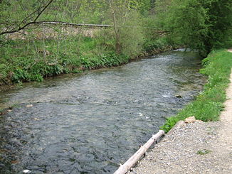
The Urspring just before its mouth |
||
| Data | ||
| location | Alb-Donau-Kreis , Baden-Württemberg , Germany | |
| River system | Danube | |
| Drain over | Oh → Blue → Danube → Black Sea | |
| source | in Schelklingen near the former Urspring Monastery 48 ° 22 ′ 53 ″ N , 9 ° 43 ′ 5 ″ E |
|
| Source height | 537 m above sea level NN | |
| Spring discharge |
MNQ MQ MHQ |
100 l / s 500 l / s 2.5 m³ / s |
| muzzle | in Schelklingen at the Ach source pot in the Ach coordinates: 48 ° 22 ′ 35 ″ N , 9 ° 43 ′ 5 ″ E 48 ° 22 ′ 35 ″ N , 9 ° 43 ′ 5 ″ E |
|
| Mouth height | 534 m above sea level NN | |
| Height difference | 3 m | |
| Bottom slope | 5.2 ‰ | |
| length | 580 m | |
| Communities | Rogue blades | |
|
The Urspring shortly after its source |
||
The Urspring is a left, 580 m long tributary of the Ach , near Schelklingen in the Alb-Donau district , Baden-Württemberg , and one of the shortest rivers in Germany.
Original source
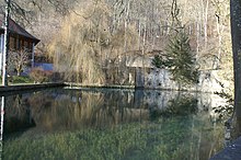
The Ursprunging spring (officially: Quelltopf Urspring ), sometimes just called Ursprung , which is located at the former Benedictine monastery of Urspring and the current Urspring School , is surrounded by a natural stone wall. The spring forms a small hill made of limestone . The karst spring pours an average of 500 liters per second (min. 100 l / s, max. 2,500 l / s). The source pot is about five meters deep. The catchment area extends to the Münsingen military training area .
course
The outflow from the spring pot takes place via two weirs that divert the stream in two arms around a building in which the school's tailoring and model-making workshop is located. Shortly after the building, the two arms reunite.
The Urspring now flows south in the valley of an Urdonau loop . Your water is fed into some fish farms there. About 500 meters below its source, a few meters east of the source of the Ach , the Urspring flows into the Ach .
See also
Web links
Individual evidence


