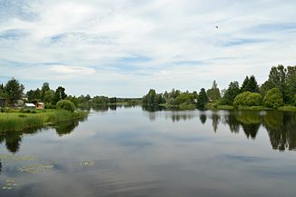
Võhandu (river)
| Võhandu | ||
| Data | ||
| location | Estonia | |
| River system | Narva | |
| Drain over | Narva → Baltic Sea | |
| source | At Saverna ( Valgjärve municipality ) 58 ° 4 ′ 40 ″ N , 26 ° 40 ′ 10 ″ E |
|
| Source height | 157 m | |
| muzzle | As Voo in the Peipussee Coordinates: 58 ° 6 '5 " N , 27 ° 33' 17" E 58 ° 6 '5 " N , 27 ° 33' 17" E |
|
| Mouth height | 30 m | |
| Height difference | 127 m | |
| Bottom slope | 0.78 ‰ | |
| length | 162 km | |
| Catchment area | 1420 km² | |
| Left tributaries | Parisoo, Karioja, Viluste, Toolamaa | |
| Right tributaries | Mügra, Kokle, Sillaotsa, Kärgula, Jaska, Rõuge, Koreli, Iskna, Palumõisa, Pahtpää, Mädajõgi , Varesmäe | |
| Flowing lakes | Lämmijärv , vagula | |
| Communities | Mikitamäe | |
| Navigable | to Võõpsu | |
The Võhandu River (Estonian: Võhandu jõgi , German: Woo ) is the longest river in Estonia .
It is 162 km long. Its catchment area covers 1420 km².
The Võhandu River has its source in the village of Saverna ( Valgjärve municipality ) and flows into Lake Lämmijärv near the village of Võõpsu ( Mikitamäe municipality ). From the upper reaches of Lake Vagula the river also bears the name Pühajõgi ("Holy River"), and from the lower reaches the name Voo . The Võhandu River is navigable from Lake Peipus to Võõpsu .
The tributaries of the Võhandu are on the right the rivers and streams Mügra, Kokle, Sillaotsa, Kärgula, Jaska, Rõuge, Koreli, Iskna, Palumõisa, Pahtpää, Mädajõgi and Varesmäe, on the left Parisoo, Karioja, Viluste and Toolamaa.
In 1963, a protected landscape area was established in the Võhandu river valley .
Individual evidence
- ↑ Topographical Map Collection Estonia, sheet 84 ( page no longer available , search in web archives ) Info: The link was automatically marked as defective. Please check the link according to the instructions and then remove this notice.

