The following important information is missing from this article or section:
Geography, population, culture, economy.
Help Wikipedia by
researching and
pasting it .
| Vacaria
|
|
-28.504444444444 -50.936666666667 971Coordinates: 28 ° 30 ′ S , 50 ° 56 ′ W
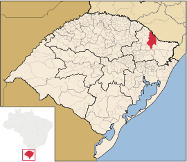
Vacaria on the map of Rio Grande do Sul
|
| Basic data
|
|
Country
|
Brazil
|
|
State
|
Rio Grande do Sul
|
|
City foundation
|
October 22, 1850
|
|
Residents
|
61,345 (Ber. 2010)
|
|
City insignia
|
|
|
|
| Detailed data
|
|
surface
|
2,123.674 km 2
|
|
Population density
|
28.89 inhabitants / km 2
|
|
height
|
971 m
|
|
Time zone
|
UTC −3
|
|
City Presidency
|
Elói Poltronieri ( PT )
|
| Website
|
www.vacaria.rs.gov.br
|
|
Location of Vacaria in Rio Grande do Sul
|
|
Center of Vacaria
|
Vacaria is a city with 61,345 inhabitants in the state of Rio Grande do Sul in southern Brazil . It is located about 240 km north of Porto Alegre . Neighboring are the towns of Lages , Monte Alegre dos Campos , Bom Jesus , Campestre da Serra , Esmeralda and Muitos Capões .
The city is known in Brazil for its climate and its production of apples.
|
Average monthly temperatures and rainfall for Vacaria
|
|
Jan
|
Feb
|
Mar
|
Apr
|
May
|
Jun
|
Jul
|
Aug
|
Sep
|
Oct
|
Nov
|
Dec
|
|
|
| Max. Temperature ( ° C )
|
24
|
24
|
23
|
20th
|
17th
|
16
|
16
|
17th
|
18th
|
20th
|
22nd
|
23
|
O
|
20th
|
| Min. Temperature (° C)
|
14th
|
15th
|
14th
|
11
|
8th
|
7th
|
7th
|
7th
|
8th
|
10
|
11
|
13
|
O
|
10.4
|
|
|
|
Precipitation ( mm )
|
170
|
170
|
140
|
114
|
130
|
132
|
142
|
165
|
165
|
145
|
124
|
130
|
Σ
|
1,727
|
T
e
m
p
e
r
a
t
u
r
|
|
|
|
|
|
|
|
|
|
|
|
|
| Jan
|
Feb
|
Mar
|
Apr
|
May
|
Jun
|
Jul
|
Aug
|
Sep
|
Oct
|
Nov
|
Dec
|
N
i
e
d
e
r
s
c
h
l
a
g
|
170
|
170
|
140
|
114
|
130
|
132
|
142
|
165
|
165
|
145
|
124
|
130
|
|
|
Jan
|
Feb
|
Mar
|
Apr
|
May
|
Jun
|
Jul
|
Aug
|
Sep
|
Oct
|
Nov
|
Dec
|
|
Diocese of Vacaria


