Varnsdorfský Špičák
| Varnsdorfský Špičák | ||
|---|---|---|
| height | 544.4 m nm | |
| location | Ústí region , Czech Republic | |
| Mountains | Lusatian highlands | |
| Coordinates | 50 ° 55 '42 " N , 14 ° 38' 48" E | |
|
|
||
| Type | Kegelberg | |
| rock | Phonolite , basalt | |
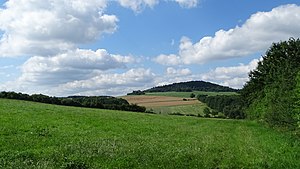
The Varnsdorfský Špičák , (German Warnsdorfer Spitzberg ) is a 544 meter high mountain in the Lusatian highlands in the Czech region of Ústí on the border with the German Upper Lusatia . It rises about two kilometers northeast of the center of the city of Varnsdorf . Up until 1966 there was a small mining hut on its phonolite dome , but today it is again wooded.
history
In 1836 it was first suspected that there must be lignite on the slopes of the mountain . As a result, mining companies were founded in Varnsdorf and Seifhennersdorf in the middle of the 19th century , but they soon had to cease operations due to the thinness of the seams and the poor yields.
Even before the end of the 19th century, there was a wooden viewing platform on the summit of Špičák. Later, the Prince of Liechtenstein granted the innkeeper Franz Kühnel the construction of an excursion restaurant with a 14 meter high observation tower, which the landlord opened on July 12, 1898. However, the building burned down on November 26, 1905. Shortly afterwards a new inn was built and opened in the spring of next year. But this too fell victim to the flames after a short time on July 5, 1915.
Not until 1930 was a smaller hut built on the mountain again. This survived the Second World War, but had to be closed in the early 1950s when a restricted zone was set up along the German-Czech border. The hut then served as accommodation for the border guards for some time, but was finally completely derelict in 1966.
Web links
- Špičák near Varnsdorf - private website about the Lusatian Mountains

