
Administrative community Thiersheim
| coat of arms | Germany map | |
|---|---|---|
 Help on coat of arms |
Coordinates: 50 ° 5 ' N , 12 ° 8' E |
|
| Basic data | ||
| Existing period: | 1978– | |
| State : | Bavaria | |
| Administrative region : | Upper Franconia | |
| County : | Wunsiedel in the Fichtel Mountains | |
| Area : | 52.3 km 2 | |
| Residents: | 4000 (Dec. 31, 2019) | |
| Population density : | 76 inhabitants per km 2 | |
| License plate : | WUN, MAK, REH , SEL | |
| Association key : | 09 4 79 5442 | |
| Association structure: | 3 municipalities | |
| Association administration address : |
Marktplatz 2 95707 Thiersheim |
|
| Website : | ||
| Community Chairman : | Bernd Hofmann | |
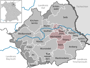
| Location of the Thiersheim administrative community in the Wunsiedel district in the Fichtelgebirge | ||
  |
||

In the administrative community of Thiersheim in the Upper Franconian district of Wunsiedel , the following communities have come together to carry out their administrative business:
- Höchstädt i.Fichtelgebirge , 1063 inhabitants, 14.95 km²
- Thiersheim , market , 1775 inhabitants, 24.42 km²
- Thierstein , market , population 1162, 12.93 km²
The administrative association founded in 1978 is based in Thiersheim. In 2013 the area of Thiersheim was enlarged by a piece of the Hohenberger Forest .
Individual evidence
- ↑ "Data 2" sheet, Statistical Report A1200C 202041 Population of the municipalities, districts and administrative districts 1st quarter 2020 (population based on the 2011 census) ( help ).
Administrative communities in the district of Wunsiedel in the Fichtelgebirge