Vincenzo A. Sagun
| Municipality of Vincenzo A. Sagun | ||
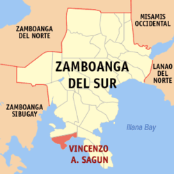
| Location of Vincenzo A. Sagun in the province of Zamboanga del Sur | ||
|---|---|---|

|
||
| Basic data | ||
| Region : | Zamboanga Peninsula | |
| Province : | Zamboanga del Sur | |
| Barangays : | 14th | |
| District: | 2. District of Zamboanga del Sur | |
| PSGC : | 097341000 | |
| Income class : | 5th income bracket | |
| Households : | 3679 May 1, 2000 census
|
|
| Population : | 23,759 August 1, 2015 census
|
|
| Coordinates : | 7 ° 31 ' N , 123 ° 9' E | |
| Postal code : | 7036 | |
| Mayor : | Edilberto S. Adlaon | |
| Geographical location in the Philippines | ||
|
|
||
Vincenzo A. Sagun is a Philippine municipality in the province of Zamboanga del Sur . It has 23,759 inhabitants (August 1, 2015 census). The Dumanquilas Bay lies partly in the administrative area of the municipality.
Barangays
Vincenzo A. Sagun is politically in 14 barangays divided.
- Ambulon
- Bui-os
- Cogon
- Danan
- Kabatan
- Kapatagan
- Limason
- Linoguayan
- Lumbar
- Lunib
- Maculay
- Maraya
- Sagucan
- Waling-waling
