Dinas (Zamboanga del Sur)
| Municipality of Dinas | ||
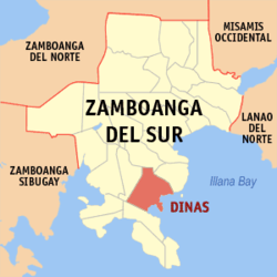
| Location of Dinas in the province of Zamboanga del Sur | ||
|---|---|---|

|
||
| Basic data | ||
| Region : | Zamboanga Peninsula | |
| Province : | Zamboanga del Sur | |
| Barangays : | 30th | |
| District: | 2. District of Zamboanga del Sur | |
| PSGC : | 097306000 | |
| Income class : | 4. Income bracket | |
| Households : |
May 1, 2000 census
|
|
| Population : | 35.504 August 1, 2015 census
|
|
| Population density : | 293.2 inhabitants per km² | |
| Area : | 121.10 km² | |
| Coordinates : | 7 ° 37 ′ N , 123 ° 20 ′ E | |
| Postal code : | 7030 | |
| Geographical location in the Philippines | ||
|
|
||
Dinas is a Filipino municipality in the province of Zamboanga del Sur on the island of Mindanao . It has 35,504 inhabitants (August 1, 2015 census) who live in 30 barangays . The community is described as rural. The name of the community is derived from the Maguindanao language, the words Di Nas do not mean unhappy .
The community of Dinas is located on the northwest coast of Illana Bay on the Baganian Peninsula , approximately 39.6 kilometers southwest of the provincial capital Pagadian City .
Barangays
|
|
|
