
Visconde de Mauá
| Região de Visconde de Mauá Visconde de Mauá |
|||
|---|---|---|---|
 |
|||
|
|||
| Coordinates | 22 ° 20 ′ S , 44 ° 32 ′ W | ||
| founding | November 24, 1924 | ||
| Basic data | |||
| Country | Brazil | ||
| State | Rio de Janeiro | ||
| Município | Resende , Itatiaia , Bocaina de Minas | ||
| ISO 3166-2 | BR-RJ | ||
| Microregion | Vale do Paraíba Fluminense (1989 to 2017) | ||
| Time zone | UTC −3 | ||

Visconde de Mauá , Portuguese Região de Visconde de Mauá (RVM), is a region that belongs to the two Brazilian states of Rio de Janeiro and Minas Gerais . It is located in the oldest national park in Brazil, the Itatiaia National Park of the Serra da Mantiqueira mountain range . Politically it is subordinate to the Riograndens cities of Resende and Itatiaia as well as in Minas Gerais Bocaina de Minas . The Rio Preto River is the border between the states.
The main towns are the villages of Vila Visconde de Mauá - the oldest town -, Vila de Maringá and Vila de Maromba . The tourist town of Vila Visconde de Mauá, also just called Visconde de Mauá, is the district seat of the Distrito de Visconde de Mauá , the fourth district of Resende. Itatiaia in the western part of the region was spun off from Resende as an independent town in 1988. The valleys Vale das Cruzes, Vale do Alcantilado, Vale do Pavão and Vale da Grama belong to it.
The main line of business is tourism with many restaurants, guest houses and holiday homes. Visitors are attracted by the many waterfalls and hiking opportunities. In addition to your own or guided hikes, there are also various possibilities to explore the area on horseback.
history
The name Visconde de Mauá goes back to the Baron (Visconde) Irineu Evangelista de Sousa , who received land as a concession for forestry in 1870 . In the following years there were quite unsuccessful attempts to settle European immigrants here, from 1908 to 1916 the colonization project Núcleo Colonial Visconde de Mauá existed . Only a few, mainly German immigrants, stayed permanently and initiated tourism from 1930. In the 1970s it was a popular destination for hippies , especially Maromba, and from 1980 it became one of the preferred mountain areas for tourists from São Paulo and Rio de Janeiro .
climate

Visconde de Mauá has a tropical mountain climate according to Köppen-Geiger Cwb. In the southern winter months of June to August, temperatures are between −2 and 13 ° C, in summer between 8 and 27 ° C with evening rain showers.
Events
- May: Festa do Pinhão e Concurso Gastronômico
- June: Festa de São João
- September: Temporada da Truta ( trout season)
Attractions
In the valleys around Visconde de Mauá, various waterfalls ("cachoeiras") can be admired:
- Cachoeira do Escorrega, the "slide waterfall" is best known, a landmark of Mauá
- Cachoeira da Santa Clara
- Cachoeira do Alcantilado
- Cachoeira do Santuário
- Cachoeira do Véu da Noiva, “Bridal Veil” waterfall
- Cachoeiras da Saudade

Santa Clara Waterfall
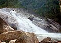
Slide waterfall

City entrance
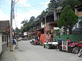
Vila Visconde de Mauá


A destination for hikes is the Pedra Selada with a height of approx. 1300 m, from which you have a beautiful view.
Transport links
The distances from the village of Visconde de Mauá to Maringá are 5.5 km, to Maromba 8.5 km, to the center in Resende 36 km and to the nearest airport 39 km ( Aeroporto de Resende , also Aeroporto Agulhas Negras, IATA : QRZ; ICAO : SDRS). The Rodovia Presidente Dutra connects the region with São Paulo and Rio de Janeiro.
Web links
- Portal to Visconde de Mauá (Brazilian Portuguese)
- Prefeitura Municipal de Resende: Visconde de Mauá (Brazilian Portuguese)
- Portal to the Região de Visconde de Mauá (Brazilian Portuguese)
Individual evidence
- ^ Prefeitura Municipal de Resende: Mapas map. Retrieved July 15, 2017 (Brazilian Portuguese).
- ↑ Visconde de Mauá: Bem-vindo a Visconde de Mauá
- ↑ Festa do Pinhão e Concurso Gastronômico
- ^ Cachoeiras , Portal to Visconde de Mauá (Brazilian Portuguese).
- ↑ Cachoeira do Escorrega
- ↑ Cachoeira da Santa Clara
- ↑ Cachoeira do Alcantilado
- ^ Cachoeira do Santuário
- ^ Cachoeira do Véu da Noiva
- ↑ Cachoeiras da Saudade