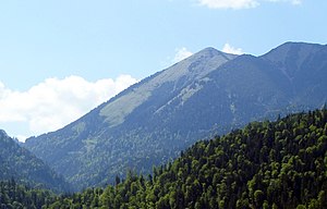
Front field head
| Front field head | ||
|---|---|---|
|
The Front Field Head from the East ( Farchant ) |
||
| height | 1928 m | |
| location | Garmisch-Partenkirchen district , Upper Bavaria , Germany | |
| Mountains | Ammergau Alps | |
| Coordinates | 47 ° 31 '49 " N , 11 ° 1' 45" E | |
|
|
||
|
The course of the ridge with the large scale head and the Vorderem Felderkopf seen from the Brünstelskopf |
||
The Vordere Felderkopf (1928 m) is a summit in the Kramer group in the Bavarian part of the Ammergau Alps, northwest of Garmisch-Partenkirchen .
Location and surroundings
The Vordere Felderkopf is the highest point of a three-kilometer-long mountain ridge running in a west-east direction, which runs here between the Kienjoch in the west and the Notkarspitze in the east. To the northeast, the Große Zunderkopf (1895 m) and the Brünstelskopf (1814 m) join; to the west the Felderkopf (1818 m) and the Windstierlkopf (1824 m).
While the mountain is mostly forested on the south side and overgrown by mountain pines in higher elevations, the steeper north side is dominated by up to 200 meter high rock faces and crags .
Hiking trails
A direct ascent leads from the Enningalm (1551 m) to the southwest in about 1.5 hours to the summit of the Vorderen Felderkopf; this can be reached in approx. 7–8 km from Farchant or Griesen . Because of this lengthy access, the Vordere Felderkopf is rarely walked, and if so, then mostly as part of a large ridge crossing.
The entire ridge is easily accessible between the Brünstelskopf in the east and the Windstierlkopf in the west. The Brünstelskopf is accessible from Farchant , Oberau ( Gießenbachtal ) or Ettal (crossing the Notkarspitze ). The Windstierlkopf can be reached from a saddle to the north, which is followed further north by another worthwhile summit, the Kienjoch . This saddle can be reached either from the west through the Elmaugrieß or from the east over the Kuhalm ; In both cases the valley location is Graswang im Ammertal.
Web links
- Front field head on Summitpost.og
Individual evidence
- ↑ a b Federal Office for Cartography and Geodesy , State Office for Surveying and Geoinformation Bavaria : Digital Topographical Map 1:50 000, BayernViewer , accessed on November 16, 2012
- ↑ Dieter Seibert: Alpine Club Guide Allgäu Alps and Ammergau Alps . Bergverlag Rother, Munich 2008, ISBN 978-3-7633-1126-2 , p. 411 .


