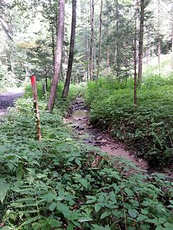
Front Jaritzbergbach
| Front Jaritzbergbach | ||
| Data | ||
| Water code | AT : STM: 4380 | |
| location | Styria , Austria | |
| Drain over | Liebochbach → Kainach → Mur → Drau → Danube → Black Sea | |
| River basin district | Mur | |
| source | in Jaritzberg 47 ° 5 ′ 24 ″ N , 15 ° 15 ′ 28 ″ E |
|
| Source height | 513 m above sea level A. | |
| muzzle | North of Sankt Bartholomä Coordinates: 47 ° 4 ′ 43 " N , 15 ° 15 ′ 29" E 47 ° 4 ′ 43 " N , 15 ° 15 ′ 29" E |
|
| Mouth height | 425 m above sea level A. | |
| Height difference | 88 m | |
| Bottom slope | 68 ‰ | |
| length | 1.3 km | |
| Communities | Saint Bartholomew | |
The Vordere Jaritzbergbach is an approximately 1.3 kilometers long left tributary of the Liebochbach in Styria . It rises north of the main town of Sankt Bartholomä , south of the municipality border with Sankt Oswald bei Plankenwarth and flows in a slight right curve to the south. To the north of Sankt Bartholomä, the L336 joins the Liebochbach a little to the west, which shortly afterwards bends to the right. On its course, the Vordere Jaritzbergbach takes on an unnamed stream from the left.
swell
- Front Jaritzbergb. In: Digital waters of the Steiermark. wis.stmk.gv.at, accessed on December 11, 2015 (German).
Individual evidence
- ↑ a b Vorderer Jaritzbergb. In: Digital waters of the Steiermark. wis.stmk.gv.at, accessed on December 11, 2015 (German).
Web links
Commons : Vorderer Jaritzbergbach - Collection of images, videos and audio files
