Vormwald (Hilchenbach)
|
Vormwald
City of Hilchenbach
Coordinates: 50 ° 59 ′ 10 ″ N , 8 ° 8 ′ 2 ″ E
|
|
|---|---|
| Height : | 409 (386-430) m |
| Area : | 7.43 km² |
| Residents : | 1033 (Jan 31, 2019) |
| Population density : | 139 inhabitants / km² |
| Incorporation : | 1st January 1969 |
| Postal code : | 57271 |
| Area code : | 02733 |
|
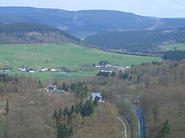
Vormwald and around the Ginsburg seen from
|
|
Vormwald is a district of the town of Hilchenbach in the Siegen-Wittgenstein district , North Rhine-Westphalia .
Geographical location
The place is located southeast of the main town in the Sauerland-Rothaargebirge nature park . The B 508 leads through it .
history
In 1417 the place name Vormwald was mentioned for the first time in the form of the personal name Heynchin vur dem Walde in the income directory of the Siegen Rentei . Today's Vormwald district of the city of Hilchenbach also includes the originally independently named farms Schreiberg, Sterzenbach and Watzenseifen. Vormwald, known under this name only since the 19th century (previously forest ), has experienced a significant increase in population since the 1970s due to the development of new residential areas. Until the municipal reorganization on January 1, 1969, the place belonged to the Keppel office .
Others
- The town is integrated into local public transport through the citizen bus .
- The kindergarten is run by the Arbeiterwohlfahrt .
- The stops in Vormwald and Vormwald Dorf are stations on the Kreuztal – Cölbe railway line , which runs through the 188 m long Vormwald tunnel near the village.
Individual evidence
- ↑ https://www.hilchenbach.de/Presse-Stadtportrait/Zahlen-Daten-Fakten/Einwohner
- ↑ Stephanie Reekers: The regional development of the districts and communities of Westphalia 1817-1967 . Aschendorff, Münster Westfalen 1977, ISBN 3-402-05875-8 , p. 290 .
- ↑ Martin Bünermann: The communities of the first reorganization program in North Rhine-Westphalia . Deutscher Gemeindeverlag, Cologne 1970, p. 70 .


