Wörth (Schliersee)
| Wörth | ||
|---|---|---|
|
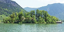
Wörth Island in Schliersee (1999) (seen from the Brecherspitz in the south) |
||
| Waters | Schliersee | |
| Geographical location | 47 ° 43 '16 " N , 11 ° 51' 42" E | |
|
|
||
| length | 260 m | |
| width | 130 m | |
| surface | 2.1 ha | |
The Wörth (from Old High German warid , Middle High German value , German 'island'), also called Insel Wörth , is the only island in the Schliersee in Bavaria .
history
The island has been inhabited since prehistoric times and its southern shore is protected as a ground monument. In the Middle Ages it was not forested and was used as pasture for sheep. The legend of the hunger tower surrounds the island . After returning from a crusade, one of the knights of Waldeck is said to have banished his unfaithful wife and her lover to the island and let them starve to death there. In the 1810s, the Bavarian original cadastre shows Wörth undeveloped and only sparsely forested, although there was already a well there. With the advent of steam shipping in the 1830s, the island received a docking point and has been used regularly since 1832. Later a restaurant was built there.
geography
The two- hectare and densely forested island is at the next point about 200 meters from the western shore of the lake. The island is the part of a massive transverse dam that rises above the water level and divides the lake into two basins.
Geologically, the island is a flysch ridge .
About 200 meters north of the island there are several shoals where comparable flych ridges reach just below the water surface.
use
The island is used for tourism, in addition to conferences and company events, mainly for wedding celebrations, which is why it is popularly known as the “wedding island”. In the northwest of the island there is the public restaurant Wirtshaus im See , as well as a boathouse and a log cabin at the western end. The island can be reached from Schliersee with the Schliersee shipping company or an island taxi .
Web links
Individual evidence
- ↑ Schliersee: How the places got their names. Retrieved May 30, 2020 .
- ↑ LfD list for the administrative districts of Upper Bavaria, Miesbach and Schliersee (.pdf)
- ↑ Press report Bayerischer Rundfunk (Video 12:02)
- ↑ Legend of the Hunger Tower
- ^ Insel Wörth on BayernAtlas Klassik
- ↑ Mentioned in 1832
- ↑ topographical-statistical description of the Tegern and Schlier lakes, 1838
- ↑ Alois Geistbeck: The South Bavarian and North Tyrolean lakes. In: Journal of the German and Austrian Alpine Association, year 1885, Volume XVI, pp. 334-354 , here pp. 345–346
- ^ Manfred Schmidt: Stream and inland lake islands in Germany. Grin Verlag, 2008, ISBN 978-3-638-95278-1 , page 22
- ↑ The Schliersee and the island of love. Münchener Zeitungs-Verlag GmbH & Co.KG, August 13, 2011, accessed on March 29, 2015 .
- ↑ Crossing to the island of Wörth. (No longer available online.) Wirtshaus im See, archived from the original on April 2, 2015 ; accessed on March 29, 2015 . Info: The archive link was inserted automatically and has not yet been checked. Please check the original and archive link according to the instructions and then remove this notice.


