Waal (Rohrbach)
|
Waal
Municipality Rohrbach an der Ilm
Coordinates: 48 ° 35 ′ 58 ″ N , 11 ° 32 ′ 38 ″ E
|
|
|---|---|
| Height : | 421 m above sea level NHN |
| Residents : | 193 (2012) |
| Incorporation : | 1st January 1971 |
| Postal code : | 85296 |
| Area code : | 08446 |
|
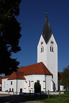
Parish church of St. Maria in Waal
|
|
Waal is a district of the municipality Rohrbach an der Ilm in the Upper Bavarian district of Pfaffenhofen an der Ilm . Until 1971 it was the seat of the municipality of the same name .
geography
The parish village of Waal is located two kilometers southwest of the core town of Rohrbach an der Ilm near the federal motorway 9 .
history
The place name "Wald" is attested as early as 1198 by the local nobility "Adelpero de Waldo", who was a ministerial officer of Count Otto von Scheyern. The Catholic Church of the Assumption of Mary, the seat of a parish until 1953, dates back to the 15th century. The nave was expanded around 1780, the tower was built in 1881 and the nave was extended in 1903.
The rural community Waal, founded in 1818 with the Bavarian municipal edict , with the associated place Ossenzhausen was incorporated into the municipality Rohrbach an der Ilm on January 1, 1971 as part of the regional reform in Bavaria .
Individual evidence
- ↑ Müller's Large German Local Book 2012. De Gruyter, 2012, page 1445.
- ↑ Waal district at www.rohrbach-ilm.de
- ^ Wilhelm Volkert (ed.): Handbook of Bavarian offices, communities and courts 1799–1980 . CH Beck, Munich 1983, ISBN 3-406-09669-7 , p. 550 .
