
Wadi-Skiffa-Clausura
| Wadi-Skiffa-Clausura | |
|---|---|
| Alternative name | Skiffa-Clausura |
| limes |
Limes Tripolitanus (back line) |
| section | Djebel Dahar |
| Dating (occupancy) | possibly late 1st or 2nd century AD or 3rd, 4th century up to 5th or 6th year |
| Type | Barrage |
| size | Length: over 1.70 km |
| Construction | Stone, pending sand and rubble |
| State of preservation | partially well preserved rubble wall |
| place | Wadi Skiffa |
| Geographical location | 33 ° 2 '11.8 " N , 10 ° 9' 13.8" E |
| height | 363 m |
| Previous |
Wadi-Skiffa-Clausura (south) (rear Limes line) (south) |
| Subsequently |
Wadi-Zraia-Clausura (rear Limes line) (north) |
| Backwards | Talalati Fort (east) |
| Upstream |
Small fort Bir Mahalla (rear Limes line) (west) |

Wadi Skiffa-Clausura , even Skiffa-Clausura , is the modern name of a small Roman barrage that for security and surveillance tasks at the rear Limes Tripolitanus , a deeply staggered system of forts and military posts, in the Roman province of Africa proconsularis later Tripolitania , responsible was. The fortifications, which were largely straightforward, belonged to the large military barrier belt that was supposed to defend the fertile coastal land of the province from attackers from the desert region and at the same time control the trade in goods for Rome. In addition, the pastoral nomads from the desert areas were prevented from coming into confrontation with the important agricultural production sites in the east of the country, in particular the Djeffara plain, through unauthorized border crossings . The debris wall of the barrage, partly still visible in the area, secured a pass road through Wadi Skiffa. This is located on Djebel Demmer between the mountain ranges of the Dahar mountains in southern Tunisia , Tataouine governorate .
location
The Clausura is located at the upper end of a dry valley, which lies around three kilometers to the north and parallel to a smaller wadi on the Djebel Demmer, a mountain group on the ridges of the Dahar. There, in the small wadi, the remains of the Wadi-Skiffa-Clausura (south) can be found today. Both valleys run downhill to the west. As with many passes over the Dahar that were already used in antiquity, a modern road leads over the pass. This route does not follow the ancient line in the further course. This moved to the small fort Bir Mahalla located on Wadi bel Recheb and further down to the small fort Tisavar located on the same wadi , which was built on the Eastern Sand Sea , the former outer border of the Roman Empire. In addition to the name Skiffa, the dry valley is also known under the name Wadi Aukoil.
Research history
The first reference to the Clausura comes from the year 1894. It was noticed by the French artillery lieutenant Henri Lecoy de la Marche during an archaeological expedition, where he made a double mistake. Mislead by his local guide, he imagined he was in Wadi Bel Recheb, who believed the barrage he had discovered here to be a Roman dam. The most important early analysis of the findings dates from 1896 and was carried out by the French explorer Paul Blanchet (1870–1900). Blanchet, who did not repeat Lecoy de la Marches' mistake, had been there in 1895. He recognized the remains of the building as barriers in the African Limes. Independently of Blanchet, the geographical error Lecoy de la Marches was also noticed in 1901 by the French captain Hilaire during his own archaeological expedition.
Between 1901 and 1902 the French archaeologist and Limes pioneer Paul Gauckler (1866–1911) researched the Limes Tripolitanus on behalf of the Tunisian antiquities administration . He was supported in this by the internal affairs department and military personnel, with whom, among other things, the preliminary planning for the desert expeditions was drawn up. Gauckler provided a more accurate picture of the gatehouse than Blanchet and took further measurements there. The French archaeologist Pol Trousset visited the facilities around 1970 and described them in 1974. As part of the UNESCO Libyan Valleys Archaeological Survey carried out between 1979 and 1989, other archaeologists, including the British David Mattingly , examined the ruins in 1982 . The upgrade of the unpaved desert road to a modern road between 2016 and 2017 took place without archaeological support. For the first time since the beginning of the research, Roman structures were destroyed in the immediate vicinity of the gatehouse.
Building history
The ostraca from the Gholaia / Bu Njem border fort in Libya , dating back to the third century AD, confirm the involvement of a regular garrison in routine police duties and the surveillance of civilians. With the Clausurae of Zraia and Skiffa the Limes section of Talalati was to be secured. The military leadership had divided the Limes Tripolitanus into several areas, which were commanded by section commanders. At the Skiffa barrage, a small unit of Roman soldiers controlled the movement of goods and secured the densely populated area of the province in the east against unauthorized border crossings. The Talalati fort, built in AD 263, was located in the eastern valley of the Dahar to secure the rear border . In the building inscription found there, this border section is referred to as Limes Tripolitanus . The barrages installed at Djebel Demmer also formed a unit with the small fort Benia bel Recheb to the north , which was in line with the dams.
The construction type of the Clausura is similar to that which was also observed on the Skiffa-Clausura further south. This can be seen, among other things, in the construction of the wall made of rubble stones, which is accompanied by larger blocks that look like "curbs". The rubble wall is between three and four meters wide in the areas that have been preserved both in the dry valley and on the ridge it occupies in the north. In the middle part, the Clausura is already badly damaged. It consisted here either of an almost completely defunct dam or of a wall, which is now also badly dilapidated. It is possible that a combined construction method was used here and a dam with a light wall was built. Where the wall met the main river bed of the wadi, the Roman engineers built artificial channels to protect it against flooding.
In his report, Blanchet mentions a cistern around five meters wide , which is also said to date from Roman times. As one of his sketches shows, it lay at the foot of the southern range of hills that the Clausura rubble rises up.
The wall begins on the southern edge of the wadi in the lower third of a steep face at almost 400 meters above sea level and drops in a straight line to the gatehouse, which is around 490 meters away, and the modern road that runs next to it, to around 370 meters above sea level. Even before that, immediately south of the cistern, Blanchet noticed a short turn off the wall in a south-westerly direction towards a spur . Trousset was unable to find any such junction during his investigations in the northern section of the wall. After the gatehouse, the barrage moves approximately 835 meters in a northerly direction through the main river bed to the foot of a significant hill at 385 meters and then rises slightly to the northeast to 390 meters. The pointed ridge of the hill now forms a slightly sloping short ridge, which is clearly inclined to the northeast, which the barrage follows to its end. Then the rubble wall climbs the next mountain slope to almost 400 meters in altitude and then breaks off.
Libyan graves, questionable watchtowers
Two circularly arranged mounds of rubble, which - while still in the plain - were already observed by Blanchet near the southern end of the Clausura and referred to as possible watchtowers, are in all probability Libyan graves, according to Mattingly. This statement is based, among other things, on a cemetery known nearby with similar, albeit usually smaller, tower structures. The cemetery was discovered in 1982 as part of the UNESCO Libyan Valleys Archaeological Survey. Not all archaeologists agree with Mattingly and so the French archaeologist Joëlle Napoli in her dissertation in 1988 went to the bottom of Blanchet's very undifferentiated statements about watchtowers along the barrage. Blanchet did not give the exact location of the towers that he claims to have observed in his writing. Since he spoke of a total of three towers, Napoli was only dependent on guesswork. It seemed to her that one of these towers had been erected directly on the east side of the barrage, which Napoli constantly refers to as the “wall”, while the other two towers must have stood hostile on the west side, in her opinion. According to Blanchet, the towers are said to have been three times wider (“trois fois plus larges”) than the wall, so they would have had a diameter of twelve to fifteen meters. There is no modern scientific evidence for these statements. According to Mattingly, a Roman-era tower could also have stood on the prominent hill at the northern end of the Clausura.
Gatehouse (Henchir Skiffa)

,_Tripolitanischer_Limes,_Libyen.svg)
Blanchet was able to identify a ruin previously known as Henchir Skiffa as a gatehouse in the south of the Clausura . The modern road passes its remains immediately north. The wall shells of the building are made of handy, rectangular cut stone, which are set very carefully. In this process, which is typical of Roman architecture, the wall core consists of rubble stones set in mortar. The gatehouse had two towers and a single-lane passage dividing them, which, according to Blanchet, was still vaulted at the time and, according to its measurements, was around four meters wide. All the outer corners of the gatehouse were rounded, but this does not reflect Blanchet's plan. Gauckler, however, was a little more precise in his description of the gatehouse. He reported that the two gate towers were best preserved and measured them to be five meters long, 2.50 meters wide and four meters high. However, Blanchet's measurements cannot be reconciled with his own plan, which was published with measurements in 1899 and appeared as a redrawing by John Wacher (there for the first time in 1987). The long side of the plan, also shown with scale at Wacher, facing the debris wall of the barrage, corresponds - measured on the outside - with the specified five meters by Gauckler. Gauckler's measurement of the tower width was then obviously made inside. With this, Gauckler confirmed the basic dimensions for the towers used by Blanchet in his drawing. However, Blanchet's four-meter-wide passage cannot be reconciled with his own plan of 1899, if further measurements are taken into account. Among other things, he originally specified the door width as 1.20 meters. Other dimensions first mentioned by Blanchet are also incompatible with those of Gauckler. In a mutual comparison of the two measurement results, the total dimensions of the gatehouse at Blanchet are initially 3.40 × 7.20 meters and at Gauckler 5.00 × 10.60 meters, if the Blanchet plan is scaled undistorted to the corresponding size. In Blanchet's report, which appeared in 1899, a standard is also given for him that corresponds to Gauckler's information and which was reprinted by Wacher, among others. According to Gauckler, the passage and the towers were covered with a barrel vault. In addition, the towers are said to have had battlements once. Trousset assumed after his investigation that this gatehouse was subsequently built into the Clausura. Mattingly was able to use the better preserved gatehouse of the Hadd-Hajar-Clausura , which also had rounded corners, to prove that the wall and the passage were built at the same time. The structural similarity of the two gatehouses is possibly also an indication of the temporal coincidence. A wide range of pottery readings could be collected at the Hadd Hajar barrage. These fragments can be assigned to the late first and second centuries AD.
The state of preservation described in the historical descriptions shows in comparison with current photographs that the remains of the gatehouse apparently suffered an enormous loss of substance between 1900 and 2018.
- Findings at the gatehouse and in the vicinity, 2018

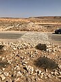
View from the western front of the south tower to the southern end of the Clausura on the hillside

Rounded corner of the south tower with the road that was expanded in 2016/2017, view from the southwest

In the inner gusset of the south tower corner, the beginnings of the barrel vault are still visible
The section of the wall that was broken out during road construction is reproduced in the asphalt with a width of 5 meters
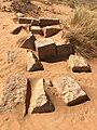
The stone already described by Paul Blanchet, which are lying in the area without a bond
-5.jpg)
-4.jpg)
-2.jpg)
-3.jpg)
-9.jpg)
Chronological order
The French archaeologist Pol Trousset assumed that the Clausura system at Djebel Demmer was created in the third century AD, while Mattingly argued for the fourth century. On the other hand, the structural similarity of the gatehouse in Wadi Skiffa with that of Hadd Hajar is a possible indication of a temporal coincidence. A wide range of pottery readings could be collected at the Hadd Hajar barrage. These fragments can be assigned to the late first and second centuries AD. Despite the previous lack of knowledge about the exact time of the establishment of the Clausurae on Djebel Demmer, it is certain that these structures were part of the border security until the late Roman period. However, there remains a further open discussion as to whether at least parts of the old border barriers in this section were reoccupied after the reconquest of North Africa by the Eastern Roman Emperor Justinian I (527-565).
literature
- David J. Mattingly : Tripolitania. Batsford, London 2005, ISBN 0-203-48101-1 , p. 188.
- Joëlle Napoli : Recherches sur les fortifications linéaires romaines (= Collection de École Française de Rome 229), École française de Rome, Rome 1997, ISBN 2-7283-0371-1 , p. 453. ( Dissertation , Paris 1988)
- Pol Trousset : Recherches sur le limes Tripolitanus, du Chott el-Djerid à la frontière tuniso-libyenne. (Etudes d'Antiquites africaines). Éditions du Center national de la recherche scientifique, Paris 1974, ISBN 2-222-01589-8 . Pp. 97, 139-141.
- René Cagnat : La frontière militaire de la Tripolitaine X l'époque romaine . In: Mémoires de l'Institut national de France. Académie des Inscriptions et Belles-Lettres , Volume 39, Paris 1914, pp. 77-109; here: pp. 87–88.
- René Cagnat: L'Armée romaine d'Afrique et l'occupation militaire de l'Afrique sous les empereurs . Imprimerie nationale, Paris 1913, pp. 534-535.
- Hilaire: Note sur la voie stratégique romaine qui longeait la frontière militaire de la Tripolitaine. Essai d'identification des gîtes d'étapes de la portion de cette voie comprise entre ad Templum et Tabuinati . In: Bulletin archéologique du Comité des travaux historiques et scientifiques . 1901, pp. 100-101.
- Paul Blanchet : Mission archéologique dans le center et le sud de la Tunisie (Avril-Août 1895) . In: Nouvelles Archives des Missions Scientifiques et Littéraires. Choix de rapports et instruction. , 9, Paris 1899, pp. 103-156; here: pp. 140, 141, 155.
Remarks
- ↑ Michael Mackensen : forts and military posts of the late 2nd and 3rd centuries on the "Limes Tripolitanus" . In: Der Limes 2 (2010), pp. 20–24; here: p. 22.
- ↑ Wadi-Skiffa-Clausura (south) at 33 ° 0 ′ 32.79 ″ N , 10 ° 9 ′ 45.6 ″ E
- ↑ Bir Mahalla small fort at 33 ° 3 ′ 21 ″ N , 10 ° 0 ′ 27 ″ E
- ↑ fortlet Tisavar at 33 ° 0 '30.97 " N , 9 ° 36' 58.38" O
- ^ Joëlle Napoli : Recherches sur les fortifications linéaires romaines (= Collection de École Française de Rome 229), École française de Rome, Rome 1997, ISBN 2-7283-0371-1 , p. 450.
- ^ David Mattingly , Barri Jones : A New 'Clausura' in Western Tripolitania. Wadi Skiffa South. In: Libyan Studies , 17 (1986), p. 92.
- ^ Paul Blanchet: Mission archéologique dans le center et le sud de la Tunisie (Avril-Août 1895) . In: Nouvelles Archives des Missions Scientifiques et Littéraires. Choix de rapports et instruction. , 9, Paris 1899, pp. 103-156; here: pp. 140, 141, 155.
- ↑ Hilaire Capt .: Note on la voie stratégique romaine qui longeait la frontière militaire de la Tripolitaine. Essai d'identification des gîtes d'étapes de la portion de cette voie comprise entre ad Templum et Tabuinati . In: Bulletin archéologique du Comité des travaux historiques et scientifiques . 1901, pp. 115-125; David J. Mattingly : Tripolitania. Batsford, London 2005, ISBN 0-203-48101-1 , p. 187.
- ^ Paul Gauckler: Le Centenarius de Tibubuci (Ksar-Tarcine, South Tunisia). In: Comptes-rendus des séances de l'Académie des Inscriptions et Belles-Lettres. 1902, pp. 321-340; here p. 321.
- ^ Pol Trousset: Recherches sur le limes Tripolitanus, du Chott el-Djerid à la frontière tuniso-libyenne. (Etudes d'Antiquites africaines). Éditions du Center national de la recherche scientifique, Paris 1974, ISBN 2-222-01589-8 . Pp. 97, 139-141.
- ↑ Robert Marichal: Les ostraka de Bu Njem . In: Comptes rendus de l'Académie des Inscriptions et Belles-Lettres (1979), pp. 436-437.
- ↑ Hédi Ben Ouezdou, Pol Trousset: Aménagements hydrauliques dans le Sud-Est tunisien . In: Contrôle et distribution de l'eau dans le Maghreb antique et médiéval . (= Collection de l'École française de Rome 426) École française de Rome, Rome 2009, ISBN 978-2-7283-0797-5 , pp. 1-18; here: p. 12 (footnote 28).
- ↑ CIL 8, 22765 .
- ↑ fortlet Benia bel Recheb at 33 ° 11 '38.2 " N , 10 ° 10' 32.9" O
- ^ A b Pol Trousset : Recherches sur le limes Tripolitanus, du Chott el-Djerid à la frontière tuniso-libyenne. (Etudes d'Antiquites africaines). Éditions du Center national de la recherche scientifique, Paris 1974, ISBN 2-222-01589-8 . P. 96.
- ^ David Mattingly , Barri Jones : A New 'Clausura' in Western Tripolitania. Wadi Skiffa South. In: Libyan Studies , 17 (1986), pp. 87-96; P. 91.
- ^ A b c d David J. Mattingly : Tripolitania. Batsford, London 2005, ISBN 0-203-48101-1 , p. 188.
- ↑ a b c d e Paul Blanchet: Mission archéologique dans le center et le sud de la Tunisie (Avril-Août 1895) . In: Nouvelles Archives des Missions Scientifiques et Littéraires. Choix de rapports et instruction. , 9, Paris 1899, pp. 103-156; here: p. 141.
- ^ Joëlle Napoli : Recherches sur les fortifications linéaires romaines (= Collection de École Française de Rome 229), École française de Rome, Rome 1997, ISBN 2-7283-0371-1 , p. 454.
- ↑ Cistern at 33 ° 2 ′ 1.79 ″ N , 10 ° 9 ′ 15.46 ″ E
- ↑ Wadi-Skiffa-Clausura - southern end point, at 33 ° 1 ′ 51.35 ″ N , 10 ° 9 ′ 17.37 ″ E
- ^ Joëlle Napoli : Recherches sur les fortifications linéaires romaines (= Collection de École Française de Rome 229), École française de Rome, Rome 1997, ISBN 2-7283-0371-1 , p. 450.
- ↑ Wadi-Skiffa-Clausura - hilltop, at 33 ° 2 ′ 37.79 ″ N , 10 ° 9 ′ 10.75 ″ E
- ↑ Wadi Skiffa-Clausura - Northeastern end, at 33 ° 2 '44.25 " N , 10 ° 9' 17.93" O
- ↑ a b c d Joëlle Napoli : Recherches sur les fortifications linéaires romaines (= Collection de École Française de Rome 229), École française de Rome, Rome 1997, ISBN 2-7283-0371-1 , p. 453.
- ↑ Wadi-Skiffa-Clausura - gatehouse, at 33 ° 2 ′ 7.33 ″ N , 10 ° 9 ′ 14.17 ″ E
- ↑ John Wacher (Ed.): The Roman World . Vol. 1, Routledge, London / New York 2002, ISBN 0-415-26315-8 , p. 251, Fig. 10.12.
- ^ Stéphanie Guédon: La frontière romaine de l '"Africa" sous le Haut-Empire . Casa de Velázques, Madrid, 2018, ISBN 978-84-9096-204-6 , p. 131.
- ^ Joëlle Napoli : Recherches sur les fortifications linéaires romaines (= Collection de École Française de Rome 229), École française de Rome, Rome 1997, ISBN 2-7283-0371-1 , p. 118.
- ^ David J. Mattingly : Tripolitania . University of Michigan Press, 1994, ISBN 0-472-10658-9 , p. 78.
- ^ Pol Trousset: Note on un type d'ouvrage linéaire de la frontière d'Afrique, dans Actes du Ie colloque international sur l'histoire et l'archéologie de l'Afrique du Nord . (Perpignan, 14-18 avril 1981), Paris 1984. pp. 383-398.
- ^ David Mattingly , Barri Jones : A New 'Clausura' in Western Tripolitania. Wadi Skiffa South. In: Libyan Studies , 17 (1986), pp. 87-96; P. 95.
- ^ David J. Mattingly : Tripolitania . University of Michigan Press, 1994, ISBN 0-472-10658-9 , p. 78.
- ^ David Mattingly , Barri Jones : A New 'Clausura' in Western Tripolitania. Wadi Skiffa South. In: Libyan Studies. Annual Report of the Society for Libyan Studies . 17: 87-96 (1986); here: p. 95.