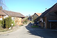
Wagerswil
| Wagerswil | ||
|---|---|---|
| State : |
|
|
| Canton : |
|
|
| District : | Weinfelden | |
| Political community : | Wigoltingen | |
| Postal code : | 8564 | |
| Coordinates : | 722 202 / 274250 | |
| Height : | 476 m above sea level M. | |
| Residents: | 127 (December 31, 2018) | |
| Website: | www.wagerswil.ch | |
| map | ||
|
|
||
Wagerswil is a village in the municipality of Wigoltingen in the Weinfelden district of the Swiss canton of Thurgau . Wagerswil is located on the southern slope of the Seerücken near the Winterthur – Konstanz motorway .
history
From the Middle Ages until 1798, Wagerswil belonged to the Lower Court of Wigoltingen, into which the rule of Altenklingen and the Dompropstei Constance were divided. From 1812 to 1994, Wagerswil and Engwang formed the local community of Engwang.
Ecclesiastically, the predominantly Reformed village belonged to the parish of Wigoltingen.
photos
Web links
Commons : Wagerswil - Collection of images, videos and audio files
- www.wagerswil.ch. Private website from Jürg Thalmann, Wagerswil
Individual evidence
- ↑ a b Localities and their resident population. Edition 2019 . On the website of the Statistical Office of the Canton of Thurgau (Excel table; 0.1 MB), accessed on April 28, 2020.
- ^ Verena Rothenbühler: Wigoltingen. In: Historical Lexicon of Switzerland .
- ↑ a b Verena Rothenbühler: Engwang. In: Historical Lexicon of Switzerland .


