
Wahrberg (Glücksburg)
Wahrberg ( Danish : Vaarbjerg ) is a place in the municipality of Glücksburg .
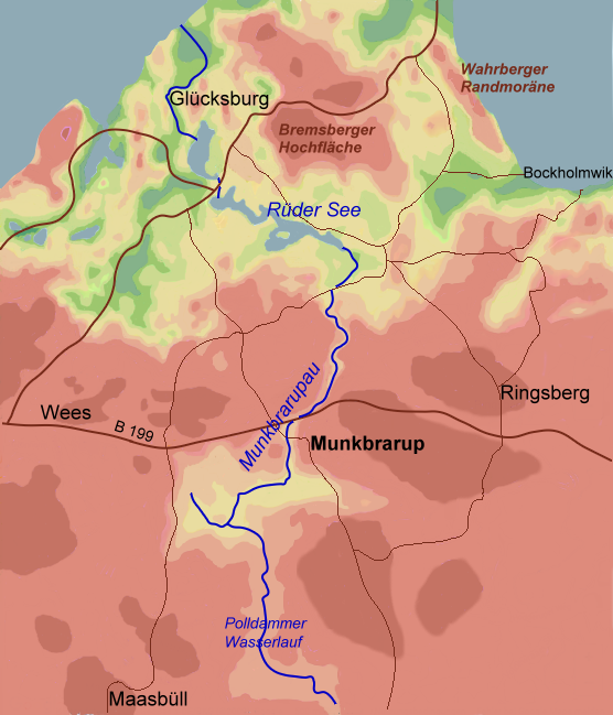
location
The street settlement is south of Bockholm , along the road of the same name Wahrberg. The houses are assigned the addresses Wahrberg No. 1, 2 and 4. In addition, some of the houses in the Bockholm / Wahrberg crossing area, which were assigned to the Bockholm street according to their house number, also belong to the Wahrberg street settlement. Iskiersand and the Munkbraruper district of Bockholmwik are south of Wahrberg . From the road Wahrberg there is also a path that leads to the Munkbrarup town of Geil ( Lage ).
background
The landscape of the Flensburg Fjord was formed in the Ice Age . In the Wahrberg area, the so-called Wahrberg rim moraine was created , which has its highest elevation at 34.8 meters to the north near Bockholm. In the Wahrberg area there was initially a single farm in Wahrberg, which was probably built on the actual Wahrberg, which is 16.5 meters high, in the days of the Rudekloster .
Wahrberg is said to have served as an observation post in the Middle Ages . From there, warships and pirate ships approaching on the fjord could be sighted, so that the population could be "warned" by fire or a rider. Because of this "warning possibility" the place got its name. Wahrberg was first mentioned in the local church registers from 1677 as "Warberg". The first known resident of Großkate Wahrberg was Margeret Thomsen, born in 1613, died in 1688 in "Warberg".
In 1905, the owner Andreas Nielsen built today's house on the site of the Wahrberg estate, with the address Warberg 2. Before that, in 1890, Nielsen had an acceptance house, i.e. retirement home, built for the family south of the farm on the opposite side of the street. In 1971/72 the Förde-Golf-Club eV Glücksburg was founded, which developed the area north and in small parts also south of the road Wahrberg as a golf course . In 1992, Wahrberg No. 4 was built from a former stable building.
Miscellaneous
- At the Ostseeman Triathlon , the bike route runs along Wahrberg.
- Other cycle routes also lead along Wahrberg.
- There is also a small stream near Wahrberg, which is apparently called the Wahrberger Au.
Individual evidence
- ↑ Flensburg district map. Land survey office Schleswig-Holstein 1970
- ↑ a b City Map Logistics, Glücksburg
- ↑ Chronicle Bockholm, Drei, Holnis, Kobbellück, Schausende . Written by a team of authors led by Telsche Henningsen, Husum 2019, pp. 96, 108
- ↑ Flensburger Tageblatt : Flensburg: Geomorphologist: Fjord instead of fjord is deceiving tourists , from: January 8, 2015; accessed on: May 1, 2018
- ↑ Location of the Wahrberg marginal moraine , accessed on: July 29, 2020
- ↑ Glücksburgkarte from 1926 , accessed on: July 29, 2020
- ↑ a b c Chronicle Bockholm, Drei, Holnis, Kobbellück, Schausende . Written by a team of authors led by Telsche Henningsen, Husum 2019, p. 205
- ↑ a b Chronicle Bockholm, Drei, Holnis, Kobbellück, Schausende . Written by a team of authors led by Telsche Henningsen, Husum 2019, p. 207
- ^ Map of Wahrberg from 1926
- ^ Gundula Hubrich-Messow: Legends and fairy tales from fishing , Husum 1987, page 57
- ↑ Chronicle Bockholm, Drei, Holnis, Kobbellück, Schausende . Written by a team of authors led by Telsche Henningsen, Husum 2019, p. 207
- ↑ Lexicon about old and no longer used terms by Helmut Ihrens in 2001 , entry: Abnahmehaus, Altteile; accessed on: July 29, 2020
- ↑ Chronicle Bockholm, Drei, Holnis, Kobbellück, Schausende . Written by a team of authors led by Telsche Henningsen, Husum 2019, p. 206
- ↑ Chronicle Bockholm, Drei, Holnis, Kobbellück, Schausende . Written by a team of authors led by Telsche Henningsen, Husum 2019, p. 52 ff.
- ↑ Förde-Golf-Club (homepage of the club)
- ↑ Chronicle Bockholm, Drei, Holnis, Kobbellück, Schausende . Written by a team of authors led by Telsche Henningsen, Husum 2019, pp. 208 and 211
- ↑ Flensburg : A lot of traffic at the Ironman Triathlon: Ostseeman 2015: It will be tight in Glücksburg on Sunday , from: July 30th, 2015
- ↑ For example: Sternroute Glücksburg and Ostsee-Radweg , each accessed on: July 29, 2020
- ↑ Beach and stones. Landscape - Geotopes - The Munkbrarupau Valley - A late glacial meltwater valley , accessed on: July 29, 2020
Coordinates: 54 ° 49 ′ 52.3 " N , 9 ° 35 ′ 55.5" E