Walder Alm

The Walder Alm (also: Walderalm ) is an Alm in the municipality of Gnadenwald in the Gleirsch-Halltal chain in the Karwendel in Tyrol .
Location and surroundings
The Walder Alm is at an altitude of 1511 m above sea level. A. on a high plateau in the Gleirsch-Halltal chain between the Hundskopf ( 2243 m above sea level ) in the west and the Walder Joch ( 1636 m above sea level ) in the east.
It can be reached from St. Martin via a toll road to the Hinterhornalm , from St. Michael via the old Walderalmweg over the Gungglkopf or via the Knappensteig from the Vomper Loch .
building
The Almanlage dates back to the 17th century and consists of a barracks and five farm buildings . The Kaser is constructed in a post construction and subsequently plastered, the farm buildings are constructed in a combed block construction. In the Kaser there is a snack station, the other buildings are used for alpine farming and some have a room that has been expanded for residential purposes.
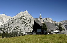
A chapel dedicated to Maria Schutz stands southeast of the alpine building . The tent-like building, erected in 1971, consists of a brick wall base with glass fronts on both sides and a gable roof that extends to the ground . The pyramid-shaped bell tower is attached to the ridge. Inside there is a modern crucifix on the gable surface above the altar.
Web links
Individual evidence
- ↑ Hike to the Walderalm , tirol.orf.at from November 8, 2013
- ↑ Walderalm , Gnadenwald community
- ↑ Schumacher, Wiesauer: Walderjoch-Alpe, Walderalm. In: Tyrolean art register . Retrieved July 19, 2016 .
- ↑ Schumacher, Wiesauer: Almkapelle, Maria Schutz chapel, Walderalm chapel, Walderalm chapel. In: Tyrolean art register . Retrieved July 19, 2016 .
Coordinates: 47 ° 20 ′ 17 ″ N , 11 ° 35 ′ 0 ″ E


