
Wangen (Starnberg)

The parish village of Wangen (about 585 inh.) Is a district of Starnberg , in the Upper Bavarian district of the same name . From 1952 to 1978 the place formed the center of an independent municipality.
location
Wangen is nestled on a hill between Forstenrieder Park in the north and the former community-free area of Wadlhauser Gräben , a very hilly, contiguous forest area in the south. In between, the A 952 runs right past the southern outskirts .
history


Was first mentioned in Wangen in the year 1010 in a document in which, by King Henry II. The Polling Abbey his old possessions, including cheeks belonged, were refunded. The place could go back to the eighth century. Between 1100 and 1250 some farms in Wangen changed hands several times between the possessions of the Wittelsbacher and the Andechs-Meranier . In the Konradinische Matrikel from 1315 the Ulrichskirche in Wangen is mentioned as one of five branch churches of the Aufkirchen pilgrimage parish . In 1734 a storm destroyed the church with the roof turret falling on the nave, two years later it was rebuilt with a roof turret.
When the municipal edict of 1808/1818 was introduced, Wangen came to Percha . After many years of efforts to create a school exposition, the royal authorities finally approved the construction of a schoolhouse, which was inaugurated in 1878. Until 1907, the church roof ridge tilted dangerously again, which is why it was replaced by today's south tower. While the number of properties and houses did not exceed a dozen or so with around 158 inhabitants up to around 1900, their number quadrupled in the following 50 years, particularly due to the opening of Olympiastrasse in 1935/1936. On February 1, 1952, the union of the northeast of the municipality of Percha and the northwest of the municipality of Schäftlarn to form the independent municipality of Wangen came into force. After the opening of the A 95 and its Starnberg feeder A 952 , Wangen experienced a further boom, as the place became interesting for commuters as a place to live. School operations in the school building, which was expanded in 1960, ended after almost a hundred years, as the Wangen primary school students were taught in Percha from autumn 1976. As part of the last wave of community reform in 1978, the short history of the community of Wangen ended again, Schäftlarn received its part of the area (except for Schorn) back, the part that came from Percha fell to the city of Starnberg on May 1st.
Infrastructure
- Public transport: MVV bus line 904 Starnberg — Percha / Leutstetten — Wangen — Neufahrn — Schäftlarn
- Public institutions: Kindergarten / day nursery and day-care center “Think with us! Zwerge ”(in the new part of the old school building), volunteer fire brigade, multi-purpose hall
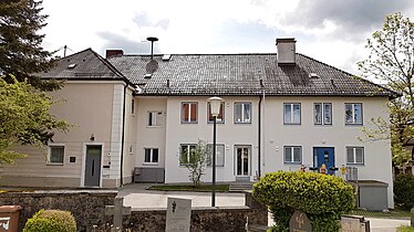
Former school house

Village shop
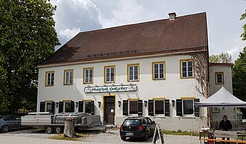
Inn


societies
- SV Wangen , popular sports club with a focus on football. Other sports: women's gymnastics, skiing, modern pentathlon, children's gymnastics and table tennis.
- Adlerschützen Wangen , on December 13, 1902, first shooting competition with 12 shooters.
- Wangen-Neufahrn brass band , founded on September 11, 1966 by 15 young men.
- Fraternity of Wangen , founded with the first Wangen May Day celebration in 1908.
- Rural youth Wangen-Neufahrn , founded in 1945/1946.
- Fruit and Horticultural Association , founded in 1959.
- Sudeten German Landsmannschaft Wangen
- Folk music group Wangen
- Village community of Wangen
Architectural monuments / sights

- Parish church St. Ulrich , late baroque building from 1736. New tower (1908) replaced the roof turret, which threatened to collapse on the church roof. Three-bay nave with a retracted, semicircular final choir. High altar from 1740 and early Baroque side altars, on the right a valuable late Gothic relief of Christ's burial place.
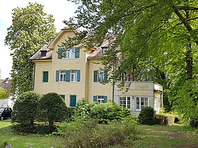
- Landhaus Albertshöhe , built in the alpine home style with roof turrets and bay windows in 1897, outside on the road to Leutstetten.
- Wildmoosstraße 10 (Kochhof) (former architectural monument), farmhouse with plastered log upper floor, high arbor and side balconies, end of the 18th century.
- Olympiastraße 26 , villa in the reduced home style (from 1907)
- War memorial from 1922 with later extensions
- Wangen is surrounded by the nature reserve "Starnberger See - Ost" (LSG-00299.01)

Ortisei, interior

Landhaus Albertshöhe

Wildmoosstrasse 10
Olympiastrasse 26

War memorial


Former municipal area
The municipality had an area of 10.83 km² and 531 (1961) and 711 (1970) inhabitants. The following places belonged to the municipality of Wangen:
- Wangen (1961: 251 Ew., 1970: 355 Ew.)
- Fercha (1961: 54 Ew., 1970: 82 Ew.)
- Neufahrn (1961: 154 Ew., 1970: 207 Ew.)
- Oberdill (1961: 12 Ew., 1970: 39 Ew.)
- Schorn (1961: 40 Ew., 1970: 12 Ew.)
- Straßer / Unterschorn (1961: 20 Ew., 1970: 16 Ew.)
literature
- Anton Brunner: 1000 years of Wangen. Kulturverlag Starnberg, 2010.
- Benno Constantin Gantner: 1200 years of Percha 785−1985. Festschrift.
Web links
- Local website of the village community of Wangen (with links to the associations)
- Wangen in the location database of the Bavarian State Library Online . Bavarian State Library
Individual evidence
- ^ Anton Brunner: 1000 years of cheeks. Kulturverlag Starnberg, 2010.
- ↑ Bavarian State Statistical Office (ed.): Official city directory for Bavaria, territorial status on October 1, 1964 with statistical information from the 1961 census . Issue 260 of the articles on Bavaria's statistics. Munich 1964, DNB 453660959 , Section II, Sp. 210 ( digitized version ).
- ^ Bavarian State Statistical Office (ed.): Official place directory for Bavaria . Issue 335 of the articles on Bavaria's statistics. Munich 1973, DNB 740801384 , p. 53 ( digitized version ).
Coordinates: 48 ° 0 ′ 43.56 " N , 11 ° 24 ′ 12.49" E