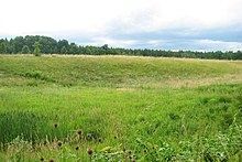
Grubmuehl (Gauting)
Grubmühl is a wasteland on the Würm near Gauting in the Starnberg district .
The area around the Grubmühle has a settlement history that goes back to the Hallstatt period , as the barrows found there, where a bronze cauldron has already been recovered, prove. There are also some raised fields from the Middle Ages . The place was first mentioned as grueb in 1399, when Konrad von Preysing sold the place. The place name refers to a mill that is located on a field that was called "pit".
In 1517 the Polling monastery was mentioned as the owner, before the mill was then given to the patrician families Part and Pütrich as an accessory to Schloss Fußberg in 1420 from Rudolf the Younger and Konrad von Preysing. In the 16th century the mill, like the Hofmark Königswiesen, belonged to Katharina Weiler, wife of Kaspar Weiler .
Old engravings and cadastral sheets show that the course of the Würm had a completely different appearance with numerous side arms, islands and widening into the 19th century. Some dry ponds near Grubmühl still bear witness to this.
In 1807, in addition to the grain mill, a sawmill was built in Grubmühl. At that time, like Solln and Königswiesen , the mill belonged to the Imperial Chamberlain and Councilor Christian Graf von Yrsch . In the middle of the 19th century, the property consisted of a house with mill buildings, a tanning mill, horse stables, a brandy distillery, a sawmill, a stamping mill , a cattle shed, a grain box and a wagon shed. In addition, the miller owned 55 days of fields, 13 days of meadows and 80 days of forest. In 1878 the mill burned down. In 1883 the grub mill was converted into a bronze factory.
Residents
Development of the population of Grubmühl:
| year | Houses | Residents |
|---|---|---|
| 1825 | 1 | 12 |
| 1880 | 1 | 12 |
| 1904 | 2 | 0 |
| 1925 | 4th | 61 |
Web links
Coordinates: 48 ° 4 ′ 58 ″ N , 11 ° 23 ′ 48 ″ E


