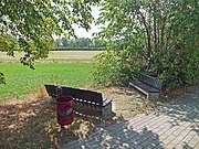
Weinteichsenke
The wine pond sink (sometimes Weinteichaue ) is a floodplain in the south of Leipzig nearby district town Markkleeberg . Because of the flora and fauna that are native to the area, an application was made for protection as a landscape protection area , but this has not yet been done.
Location and description
The Weinteichsenke is part of the Markkleeberg districts of Markkleeberg-Ost and Wachau . A small part belongs to the Dölitz-Dosen district of Leipzig and is part of the Lößnig-Dölitz landscape protection area. The Weinteichsenke is the catchment area of the Weinteichgraben, which is not always water-filled. This rises at the Wachau Woods east of Wachau, initially runs through Wachau and, after flowing through the floodplain in Markkleeberg-Ost, flows into the Kleine Pleiße .
The wine pond basin covers an area of around 1.2 km². About 25% of it is forest and meadow area, the rest is field. The wooded area, a deciduous forest, is located in the northwest part of the Weinteichsenke. Sometimes only this part is seen as a wine pond depression. The wine pond depression has been criss-crossed by asphalted or paved bike paths with benches to rest since 2006.
The Weinteichaue is the refuge of numerous threatened and rare animal and plant species. In the central Bachauenbereich following breeding birds are native: Red-backed Shrike , Yellow Wagtail , partridge , grasshopper warbler , reed bunting , reed and marsh warbler , garden and Dorngrasmücke and endangered Barbastelle and butterfly species dusky large blue . The flora here includes the real black poplar and the butterbur .
Names and history
The origin of the name is not clear. The Weinteichgraben used to flow through two ponds in Wachau. If there were pastures here , a derivation of willow pond through linguistic grinding over willow pond to wine pond would be a possible interpretation.
During the Battle of Nations in October 1813, the area around the Weinteichsenke was included in the fighting. Today, battle re-enactments of the Battle of the Nations take place here. A special highlight was the 200th anniversary of the battle in 2013.
Importance and threat
The Weinteichsenke is one of the last remaining Pleißenbach meadows in the south of Leipzig. Other tributaries of the Pleiße that also run in an east-west direction, such as the Domgraben and Trenkengraben in Leipzig, have already disappeared due to the development at the end of the 19th / beginning of the 20th century. The Weinteichaue is connected to the ecosystem of the Leipzig floodplain forest, which extends in a north-south direction, and is an important area for fresh air and cold air. The Weinteichaue is the refuge of numerous threatened and rare animal and plant species. Thanks to the cycle path network and benches, the Weinteichsenke also has a recreational character.
The area was threatened by road construction as early as the late 1990s. The extension of the state road S46 with a connection to the Wachau industrial park east of the floodplain should lead through the Weinteichsenke. The road was removed from the state development plan of Saxony in 2013 because of the newly built A38 motorway nearby .
In January 2017, the Leipziger Verein Ökolöwe applied for a protected nature reserve . The application has not yet been processed by the environmental office of the Leipzig district. In contrast, the city of Markkleeberg is planning a residential development on the southern edge of the Weinteichsenke and also an expansion of the Wachau industrial park. Since these arable areas are east of Wachau in the catchment area of the source of the Weinteichgraben, an increase in the building density in the area could cause the stream to dry up completely, similar to the fate of the aforementioned streams.
Web links
- Radio Blau : Investigative report on planned developments in the Weinteichsenke, broadcast on December 18, 2019.
- The Weinteichsenke in Markkleeberg. Retrieved August 14, 2019 .
Individual evidence
- ^ Andreas Höhn; Harald Kirschner: Markkleeberg: turbulent times ; 1990-2000 . Pro Leipzig, Leipzig 2001, ISBN 3-9806474-9-8 .
- ↑ Diana Härtrich; Thomas Nabert: Markkleeberg: History and Change . Pro Leipzig, Leipzig 2009, ISBN 978-3-936508-48-2 , pp. 211 .
- ↑ The planning of the S 46 is finally deleted from the state development plan of Saxony. In: The Weinteichsenke in Markkleeberg. Retrieved August 13, 2019 .
- ↑ Application for protection of Weinteichaue. 2017, accessed September 4, 2019 .
- ↑ Overview map for the protection of the Weinteichaue. 2017, accessed September 4, 2019 .
- ^ City of Markkleeberg: PDF on the model. Retrieved August 13, 2019 .
- ↑ Gislinde Redepenning: Markkleeberg-Wachau: Globus hardware store wants to build new and bigger. Retrieved August 13, 2019 .
- ↑ sysadm: radio article Weinteichsenke on Radio Blau | The Weinteichsenke in Markkleeberg. Accessed January 7, 2020 (German).
Coordinates: 51 ° 16 ′ 45.8 ″ N , 12 ° 24 ′ 47.1 ″ E


