
Wernerwald
Coordinates: 53 ° 51 ′ 24 " N , 8 ° 35 ′ 46" E

The Werner forest is about 315 hectares large forest on the city of Cuxhaven in Lower Saxony , Germany . The forest lies between the districts of Sahlenburg , Holte-Spangen and Arensch .
The Wernerwald is - next to a forest near Dangast and Sankt Peter-Ording - the only forest area in Germany that is located directly on the North Sea coast . Mainly pine trees grow on the sandy soil . The Wernerwald has been under landscape protection since January 5, 1939 . It contains the Finkenmoor and a pond that is fed from underground springs . As a local recreation area , it is criss-crossed by many hiking and riding trails and is particularly popular with locals, but also with tourists .
history
The forest was created at the end of the 19th century by the then Ritzebüttel official administrator Charles Anthony Werner (term of office 1868-1891) to protect against storm surges on a heather area . The original name was "Sahlenburger Revier". In the vernacular, however, it was soon called "Wernerwald", which is the only common name today.
photos

View of the North Sea from the Wernerwald

The Finkenmoor in the Wernerwald
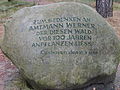
Memorial stone bailiff Werner


literature
- Günter Wolter: The Wernerwald. Series of publications by the Society for Nature and Environmental Protection Cuxhaven e. V. (GNU), Issue 6, Verlag Cuxhavener Nachrichten, Cuxhaven 1980
Web links
Individual evidence
- ↑ See Hamburg State Calendar for the year 1865, official edition, Th. G. Meißner, Hamburg 1865, p. 97; Negotiations between the Senate and the citizenship from 1890, Lütcke & Wulff, Hamburg 1891, pp. 17, 54, 566.