Westensee
| Westensee | ||
|---|---|---|

|
||
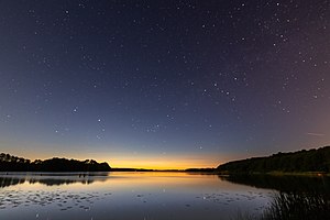
| The Westensee from the bathing area in Wrohe | ||
| Geographical location |
District of Rendsburg-Eckernförde Schleswig-Holstein |
|
| Tributaries | Eider from Schulensee Börnerbek ("Schierenseebach") from Kleiner Schierensee | |
| Drain | through the Eider and Achterwehrer Schifffahrtskanal in the Kiel Canal |
|
| Location close to the shore | Kiel | |
| Data | ||
| Coordinates | 54 ° 16 '58 " N , 9 ° 56' 44" E | |
|
|
||
| Altitude above sea level | 3 m above sea level NN | |
| surface | 6.922 km² | |
| volume | 41,630,000 m³ | |
| scope | 22.8 km shore length | |
| Maximum depth | 17.6 m | |
| Middle deep | 6.1 m | |
| Catchment area | 256.55 km² | |
The Westensee (height 3 m above sea level ) is located in the Achterwehr office in the Rendsburg-Eckernförde district . It is the fifth largest lake in Schleswig-Holstein and is characterized as a lime-rich lowland lake with a relatively large catchment area without pronounced temperature stratification . With its location between the cities of Kiel and Rendsburg , it forms the center of the Westensee Nature Park . It drains via Schleswig-Holstein's largest river, the Eider , and also reaches the Kiel Canal via the Achterwehrer Schifffahrtskanal .
description
The Westensee was formed as a tongue basin at the end of the last ice age, the Vistula Ice Age . The basin is surrounded by walls of high terminal moraines . In the south it is bounded by the Tüteberg (height 88 m above sea level ).
The construction of the Kiel Canal at the end of the 19th century led to a lowering of the lake's water level by around 75 cm. The former bank edge can still be seen in many bank areas. The areas that have fallen dry due to subsidence are now mostly swampy and overgrown with scrub forest. As a result, the nearby peat lake in particular has now completely disappeared.
The Westensee is used as a recreational body of water, although motor vehicles are not permitted. Use by non-motorized pleasure craft is regulated. You can cross the lake in the course of the Eider, but for trips in the lake you either have to live in a local community or pay a usage fee. The lake has bathing areas in Westensee , Hohenhude , Wrohe and Wulfsfelde .
See also
literature
- Uwe Muuß, Marcus Petersen u. Dietrich König: The inland waters of Schleswig-Holstein . Wachholtz-Verlag, Neumünster 1973 ISBN 3529053023
- W. Schütz, C. Frieling, M. Nordhus and H. Roweck: Vegetation and limnological investigations in Westensee, Ahrensee, Großem and Kleinem Schierensee (PDF file; 5.58 MB). Institute for Water Management and Landscape Ecology, Christian-Albrechts-University, Kiel 1993. Schr. Naturwiss. Ver. Schleswig-Holst. Vol. 63, 42 pp.
Web links
Individual evidence
- ↑ Territory information
- ↑ Eider river description (Obere Eider)
- ↑ Bathing water quality community bathing point Westensee
- ↑ Bathing water quality at the Hohenhude community bathing area
- ↑ Bathing water quality at the Wrohe municipal bathing area
- ↑ Bathing water quality community bathing point Wulfsfelde
