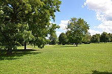
Westpark (Nuremberg)

The Westpark , the fourth largest public park in Nuremberg , is located in the west of the city.
location
The Westpark is located in the Sündersbühl district and is divided by Von-der-Tann-Straße into western and eastern parts, which are connected by a pedestrian bridge. In the west, the park turns into an agricultural area , which is already in the Höfen district in the Gaismannshof district . In the north the park area borders on several allotment gardens, in the east on a nursery.
The eastern part of the Westpark borders the Reichow settlement in the south. In the south of the western part, the Village am Westpark was built in 2002 , a development with around 200 single-family houses and a few smaller multi-family houses.
history
In 1956 a large Germany-wide city expansion program began, in the course of which the first plans for the Westpark between Fürther and Rothenburger Strasse were started. In 1966 the construction of the ensemble Parkwohnanlage West began , which is often referred to as the Reichow settlement after its planner . Today it is considered a monument to organic building. The establishment of the Westpark did not begin north of the Reichow settlement until 1970.
The park was planned as a large recreational area for the south-western districts (such as Sündersbühl and Höfen ) of Nuremberg. In addition to the public green spaces, dedicated open spaces such as allotment gardens and sports facilities were integrated into the recreation area, based on the Volkspark concept.
The Westpark is still unfinished because the city has not acquired a large number of properties, so some areas west of Von-der-Tann-Straße have not yet been developed.
In the “Compact Green Nuremberg Action Plan - 2020”, the West Park is a component of the south-west green corridor, from the Pegnitz Valley via the West Park to the Hainberg .
Furnishing
A sculpture made of square steel tubing with the name HU 185 by Alf Lechner from 1970 adorns the eastern part of the West Park. In 1971 the steel sculpture was designed as part of the international Urbanum symposium. Not far from this sculpture, a playground with a large climbing frame was set up.
In the western part there is a football and soccer field as well as a table tennis table. In this part, two granite steles were placed along a so-called ley line as part of a lithopuncture project .
Between Bertha-von-Suttner-Strasse and Lehrberger Strasse there is a 2.5 km running course in the Westpark, known as the “Sparkassenrunde”.
Transport links
There is a parking lot in the eastern part of Von-der-Tann-Straße, by the pedestrian bridge. There are also two bus stops on line 35 at this bridge. The signposted 8.6 km south-west-green route leads from Nuremberg main station , Plärrer over the Westpark to Großreuth near Schweinau , Gebersdorf and ends in the Rednitz Valley .
Web links
Individual evidence
- ↑ a b SculpTour Nuremberg. World-of-Form. Retrieved September 28, 2014 .
- ↑ Open space master plan - City- wide open space concept Nuremberg (GFK). www.nuernberg.de, accessed on September 28, 2014 .
- ^ City map service. City of Nuremberg, accessed on September 28, 2014 .
- ↑ New "Village" at Westpark. WiM - Wirtschaft in Mittelfranken, edition 11/2001, page 38, accessed on September 28, 2014 .
- ↑ E-5-64-000-35: Ensemble Parkwohnanlage West. Bavarian State Office for the Preservation of Monuments, accessed on September 28, 2014 .
- ^ Environment Agency: Compact Green Nuremberg Action Plan - 2020. www.nuernberg.de, accessed on September 28, 2014 .
- ↑ 40 years Symposion Urbanum. City of Nuremberg, Construction Department, 2011, accessed on July 20, 2017 .
- ↑ In the West Park. norisgeo.de, accessed on August 6, 2014 .
- ↑ Walking, walking, running and jogging in Nuremberg. City of Nuremberg, accessed on September 28, 2014 .
- ↑ Signposted bike routes. (No longer available online.) Nuremberg traffic planning, archived from the original on September 8, 2014 ; accessed on September 28, 2014 . Info: The archive link was inserted automatically and has not yet been checked. Please check the original and archive link according to the instructions and then remove this notice.
Coordinates: 49 ° 26 ′ 42.7 " N , 11 ° 2 ′ 13.2" E

