Wetterberg (Saxony)
| Wetterberg | ||
|---|---|---|
| height | 211 m above sea level HN | |
| location | Germany , Saxony | |
| Mountains | Lößnitzberge , Moritzburger Kuppenland | |
| Coordinates | 51 ° 8 '4 " N , 13 ° 41' 44" E | |
|
|
||
| Type | Knoll | |
| rock | Syenite | |
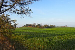
The Wetterberg is a 211 meter high knoll in the Saxon district of Meißen , near the state capital Dresden .
Location and surroundings
The Wetterberg is located at the eastern exit of the Moritzburg district of Reichenberg . The 240 meter high Gallberg rises in Boxdorf about two kilometers south of the summit . Other places near the Wetterberg are the mountain settlement Lößnitzhochland , Dippelsdorf and the Volkersdorfer settlement Neuvolkersdorf (at the Niederen Waldteich).
The Wetterberg water that rises on the Wetterberg feeds the Dippelsdorf pond to the west ; it thus forms the upper reaches of the Lößnitzbach .
view
The summit of the Wetterberg offers an expansive view of the Moritzburg small peaks landscape and the kettles and hollows that are cultivated as meadows or filled with ponds, as well as the peaks and ridges used as fields.
geology
The Wetterberg consists of syenite rock . The forest-free summit rises 15 meters above its surroundings as one of many similar ones, formed by the Pleistocene inland ice. The rock came up as melt in a younger section of the Carboniferous from below.
history
On the southern upper and middle slope as well as on Syenit penetrations at the foot there are farms and single houses, which together with several apartment buildings from the 1930s form an almost complete row to Reichenberg. One kilometer southeast of the Wetterberg, in the vicinity of the fork in the paths to Boxdorf and the forest ponds, a Bronze Age settlement was found. The associated burial ground is right next to it. Around the middle of the 19th century, vines were still growing on the mountain .
Development
Part of the summit is built on with a two-family house. A small dirt road branches off from Volkersdorfer Straße towards the summit.
literature
- Lössnitz and Moritzburg pond landscape (= values of our homeland . Volume 22). 1st edition. Akademie Verlag, Berlin 1973.

