
Wettersteinwand
| Wettersteinwand | ||
|---|---|---|
 Wettersteinkopf, Wettersteinwand and Rotplattenspitze (seen from Seefeld) |
||
| height |
2484 m above sea level A. 2482 m above sea level NHN |
|
| location | Bavaria , Germany ; Tyrol , Austria | |
| Mountains | Wetterstein Mountains , Northern Limestone Alps | |
| Dominance | 3.3 km → signal summit | |
| Notch height | 119 m ↓ Meilerhütte | |
| Coordinates | 47 ° 25 '20 " N , 11 ° 10' 1" E | |
|
||

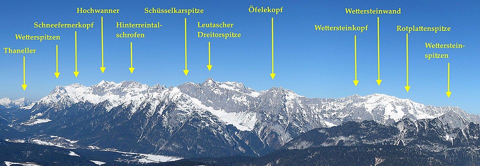
The Wettersteinwand is a 2484 m above sea level. A. (according to Austrian surveying) or 2482 m above sea level. NHN (according to German measurements) high summit in the eastern part of the Wetterstein Mountains . It represents the highest point of the Wettersteingrat east of the Meilerhütte . The entire massif from the Mittagscharte to the Drei Scharten is often referred to as the Wettersteinwand, which contains the two little protruding peaks of the Wettersteinkopf ( 2429 m ) and Rotplattenspitze ( 2399 m ). The border between Bavaria and Tyrol runs over the ridge of the Wettersteinwand.
There are numerous climbing options. Usually the summit is visited in the course of crossing the Wettersteingrat. Alternative climbs include from the Bergleintal over the Wettersteinkopf or through the Kar "Im Flecken" over the Rotplattenspitze.
The Wettersteinwand in the Wetterstein main ridge

Literature and maps
- Alpine Club Map 1: 25,000, sheet 4/3, Wetterstein and Mieminger Mountains, eastern sheet
- Stephan Beulke: Wetterstein. A guide for valleys, huts and mountains (= Alpine Club Guide . Series: Northern Limestone Alps. ). Written according to the guidelines of the UIAA. 4th, unchanged edition. Bergverlag Rother, Munich 1996, ISBN 3-7633-1119-X .