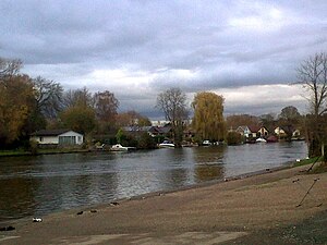
Wheatley's Ait
| Wheatley's Ait | ||
|---|---|---|
| Part of the southern part of Wheatley's Ait | ||
| Waters | Thames | |
| Geographical location | 51 ° 24 ′ N , 0 ° 25 ′ W | |
|
|
||
Wheatley's Ait or Wheatley Eyot is a Werder in the Thames about 8 hectares in size above Sunbury Lock. The island is in the post town of Sunbury-on-Thames , but its administration is in the Borough of Elmbridge in Surrey , England .
Scotland Eyot is an earlier name of the island. It belonged in the 19th century to Thomas Vincent, a large landowner from Shepperton who was a relative of Edgar Vincent, 1st Viscount D'Abernon .
In the 2001 census, 31 houses and 12 uninhabited holiday homes were counted on the island.
description
The island is divided into two parts, which are connected by a weir . In the upstream part there are houses, boat workshops and an Environment Agency dock. This part of the island can be reached by car from the mainland. The downstream part of the island is connected to the other part of the island by a pedestrian bridge and a private footbridge connects it to Sunbury Lock Ait . On the upstream part of the island there are residential and weekend houses.
The River Ash flows into the Thames at the upstream end of the island.
Postcodes
- TW16 6BU
- TW16 6DA
See also
Individual evidence
- ↑ a b c 2001 Census Output Area E00154841
- ^ A b Fred S. Thacker: The Thames Highway. Volume II: Locks and Weirs. 1st edition. David & Charles, Newton Abbot 1968, ISBN 0-7153-4233-9 . (First edition 1920)
- ^ Geo WF Claxton: The Creek Sunbury-on-Thames and Its Immediate Environment. Sunbury & Shepperton Local History Society, 1984.
- ^ Property Owners and Tenants of Sunbury in 1848. Sunbury & Shepperton Local History Society, ISBN 0-905178-13-0 .
- ↑ Spelthorne Map showing extent of the adjoining borough and Site of Nature Conservation Importance (SNCI) status of most of the River Thames and The Creek identified at the Surrey Wildlife Trust and Surrey County Council on cartogold.co.uk

