Wijdewormer
 flag |
 coat of arms |
| province |
|
| local community |
|
|
Area - land - water |
16.69 km 2 16.18 km 2 0.51 km 2 |
| Residents | 1,370 (Jan. 1, 2017) |
| Coordinates | 52 ° 29 ′ N , 4 ° 52 ′ E |
| prefix | 0299 |
| Postcodes | 1451, 1456, 1458, 1461, 1509, 1511, 1531, 2523 |
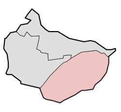
| Location of Wijdewormer in the municipality of Wormerland | |
Wijdewormer is a district of the municipality Wormerland in the Dutch province of North Holland .
geography
The district of the local part includes the same polder and a smaller border area north of Ringvaart . This is the historical location of Neck and the surrounding lands that used to belong to Purmerend .
history
The place was created in 1626 by draining the Wormer Sea and the newly created polder De Wijde Wormer .
From a village a community of the same name was created in 1817 and this remained independent until 1991, together with Jisp and Wormer, in the newly established community of Wormerland.
Web links
Commons : Wijdewormer - collection of images, videos and audio files
- Wijdewormer in the Genealogical Directory of Places
- Official website of the municipality (Dutch)
- Historical map from 1867 (Dutch)
Individual evidence
- ↑ Kerncijfers wijken en buurten 2017 Centraal Bureau voor de Statistiek , accessed on May 19, 2018 (Dutch)
- ↑ a b De Wijde Wormer. In: Wijde Wormer Journaal. Retrieved July 28, 2014 (Dutch, historical map).
- ↑ a b De oorsprong van Wijdewormer en het dorp Neck. Stichting Cultuurhistorie Wijdewormer, accessed on April 18, 2017 (Dutch).
- ^ Wijdewormer. In: Waterlands Archief. Centrum voor regionaal historically onderzoek, accessed on February 24, 2016 (Dutch).
