Wormer (Wormerland)
 flag |
 coat of arms |
| province |
|
| local community |
|
|
Area - land - water |
16.07 km 2 12.07 km 2 4 km 2 |
| Residents | 13,145 (Jan. 1, 2017) |
| Coordinates | 52 ° 30 ′ N , 4 ° 49 ′ E |
| Important traffic route |
|
| prefix | 075 |
| Postcodes | 1121, 1456, 1509, 1521, 1525, 1531 |
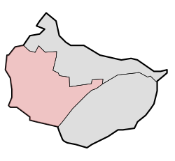
| Location of Wormer in the municipality of Wormerland | |
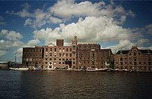
| View of Wormerveer | |
Wormer is a district of the municipality Wormerland in the Dutch province of Noord-Holland .
geography
The village is twelve kilometers north of Amsterdam and eleven kilometers west of Purmerend . The center is made up of the four parts of Westeinde, Plaszoom, Molenbuurt and Middentil. The surrounding districts and settlement areas are Oostknollendam , Oosteinde and Engewormer , as well as the statistically irrelevant Bartelsluis .
Clockwise, the district borders in the north on Markenbinnen , Starnmeer , Spijkerboor and Jisp , in the east on Wijdewormer , in the south on Zaandam and in the west on Wormerveer and West-Knollendam .
There is a 144 meter high transmission tower in Wormer .
history
Wormer is probably one of the oldest villages in the Zaan region . Some assume that the place is noted in a manuscript from the ninth century as uueromeri . The settlement was evidently listed in 1063 by the Egmond monastery under the name Weremere .
The village was independent for a long time, except between 1518 and 1611 when it was merged with Jisp. The place finally lost its independence in 1991 when it was merged with Jisp and Wijdewormer to form the new municipality of Wormerland.
Personalities
- Piet de Wit (* 1946), cyclist
Web links
- Wormer in the Genealogical Directory (German)
- Official website of the municipality (Dutch)
- Historical map from 1869 (Dutch)
Individual evidence
- ↑ a b c Kerncijfers wijken en buurten 2017 Centraal Bureau voor de Statistiek , accessed on May 19, 2018 (Dutch).
- ↑ a b Wormer. In: Waterlands Archief. Centrum voor regionaal historically onderzoek, accessed on February 24, 2016 (Dutch).


