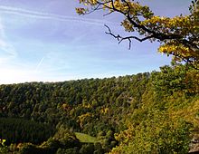
Wilhelmsblick
The Wilhelmsblick im Harz is a lookout point near Treseburg in the Bodetal in the Harz district , Saxony-Anhalt .
Geographical location
The Wilhelmsblick is located in the Harz / Saxony-Anhalt Nature Park about 1,000 m (as the crow flies ) north-north-west of the junction of Landesstraße 94 ( Altenbrak –Treseburg) from the L 93 ( Allrode –Treseburg– Wienrode ) in Treseburg, the latter connecting via the nearby district road 1350 to Thale . It is located west of the L 93 on a narrow mountain ridge at 314 m above sea level that the Bode passes on both sides . NN . The Bode is near the bridge of the L 94, which is a little southwest of the lookout point, at 273.7 m above sea level. NN and a little northeast of the viewpoint in a valley bend at 256.7 m above sea level. NN . The soil sections on both sides of the ridge are only about 150 m apart.
A little south of the Wilhelmsblick is the Dobblers Höhe .
description
The Wilhelmsblick was created in 1861 in the course of the construction of the road through the Bode valley under the direction of the road builder Wilhelm, who gave the viewpoint its name, whose former name Krügers Höhe has largely been forgotten today. He had the 22-meter-long Wilhelmsblick tunnel dug through the rock massif there in order to get to the view on the opposite side. Beyond the tunnel, a path with a few wooden steps leads up to the viewpoint above the Bode und Straße. From there the view falls on both sides of the mountain ridge into the Bode valley, although the viewpoint is largely overgrown; therefore, in the cold season, when the trees and bushes are bare, there are good prospects.
The Wilhelmsblick is included as No. 66 in the system of stamping points of the Harz hiking pin.
Individual evidence
- ↑ a b Harzer Wanderadel: stamp point 66 / Wilhelmsblick (viewpoint) , on harzer-wandernadel.de
- ↑ a b c Saxony-Anhalt viewer of the State Office for Surveying and Geoinformation ( notes )
Web links
- The Wilhelmsblick , on harzlife.de
Coordinates: 51 ° 43 ′ 24.3 " N , 10 ° 57 ′ 56.7" E
