Wilson's Promontory
| Wilson's Promontory | ||
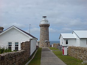
 The Wilsons Promontory Lighthouse |
||
| Geographical location | ||
|
|
||
| Coordinates | 39 ° 5 '55 " S , 146 ° 23' 12" E | |
| Waters 1 | Bass Street | |
 Tidal River viewed from the top of Mount Oberon. The Tidal River settlement can be seen at the bottom right. |
||
The Wilsons Promontory is a peninsula in the state of Victoria , which is located in the southernmost part of the Australian continent . South Point is the southernmost point of mainland Australia where the Wilsons Promontory Lighthouse is located.
history
The Aborigines of Gunai-Kurnai and Boonerwrung clans lived demonstrably since 6500 years in this field. The Wilsons Promontory National Park located there today is of great importance to them.
The first European to see this area was George Bass in January 1798. He called it Furneaux Land in his diary because he initially believed that Tobias Furneaux had seen this area before him. But when he got back to Port Jackson, Sydney, he consulted Matthew Flinders , who told him that this area must be different as it was very different from the Furneaux Archipelago. Bass and Flinders changed the name to Wilsons Promontory at the suggestion of Governor John Hunter , in memory of Flinders' London friend Thomas Wilson. Little is known about Wilson, he was a trader from London who did business with Australia.
On the peninsula is located since 1898 a National Park , the Wilsons Promontory National Park , which is also known locally as the Prom is known and comprises the largest wilderness on the coast of Victoria. The area was inaccessible to the public during World War II because it was used as a training area. The only settlement on Wilsons Promontory is Tidal River , which is 30 km south of the park boundary, a place for recreation seekers and tourists. The park is operated by the Parks Victoria company.
In 2005, about 13 percent of the park area was on fire when a park employee lit a fire and it got out of hand. In 2009, lightning created a bushfire at Sealers Cove that burned 25,000 acres. Most of the entire area hadn't burned since 1951. The fire started on February 8, 2009 , known as Black Saturday , when hundreds of bushfires started in Victoria during prolonged heat . Although the fire came within a kilometer of the Tidal River site, the park's administration building and the campsite facilities remained undamaged. The park reopened just a month later and the burned area was green again in the meantime and the natural beauty of this area was restored.
geography
The core of the peninsula des Wilsons Promontory consists of granitic mountain ranges which, with Mount Latrobe, reach a height of 754 m above sea level. Wilsons Promontory is separated from the hills and highlands of the South Gippsland region to the north of the peninsula by the low Yanakie Isthmus, which is shaped by Aeolian sands. The vegetation of the peninsula is very diverse, including temperate rainforests , dry hardwood forests and bush formations.
The coastal landscape is characterized by mudflats , sandy beaches and sheltered bays, which are interrupted by granite headlands and cliffs in the south and coastal dunes and swamps behind.
climate
|
Average monthly temperatures and rainfall for Wilsons Promontory
|
||||||||||||||||||||||||||||||||||||||||||||||||||||||||||||||||||||||||||||||||||||||||||||||||||||||||||||||||||||||||||||||||||||||||||||||||||||||||||||||||||||||||||||||||||||
Rivers
The Tidal River is the main river on Wilsons Promontory, which flows into Norman Bay. This river ebbs and swells depending on the tidal range. The river has a red-yellowish water, which results from the South Sea myrtle growing on the bank coloring the water with tannin and giving the river water a tea-like appearance.
fauna
Wilson's Promontory is home to numerous mammals, birds and other living things. The most widespread is the wombat , which is common in the park, especially around the campsites, where it invades the tents in search of food. On the peninsula there is also kangaroos , wallabies , koalas , Longnose potoroo ( Potorous tridactylus ), which Weißfüßige Schmalfuß bag Mouse ( Sminthopsis leucopus ), Australian wide-tooth rat ( Mastacomys fuscus ) acrobatidae ( Acrobates pygmaeus ) and Great Emus . There are also several species that did not originally belong to the Australian fauna, such as foxes , feral cats and rabbits .
The most common birds on the peninsula are the Pennant Parakeet ( Platycercus elegans ), Black-tailed Black Cockatoo ( Calyptorhynchus funereus ), Starling , Blackbird and Malrus .
Web links
Individual evidence
- ↑ Wilson's Promontory . In: Gazetteer of Australia . Geoscience Australia. Archived from the original on June 5, 2011. Retrieved September 10, 2010.
- ↑ Aboriginal Cultural Heritage, Victoria Parkweb
- ↑ A Voyage to Terra Australis - Volume 1 by Matthew Flinders on gutenberg.org . Retrieved September 10, 2010
- ↑ The Life of Captain Matthew Flinders by Ernest Scott on gutenberg.org . Retrieved September 10, 2010.
- ↑ Information on parkweb.vic.au . Retrieved September 10, 2010.
- ↑ information on abc.net.au . Retrieved September 10, 2010.
- ↑ Firefighters continue to battle Wilson's Prom blaze at theage.com.au . Retrieved September 10, 2010.
- ↑ Wilson's Promontory to reopen this weekend . Retrieved September 10, 2010.
- ↑ illustrations and information on smh.com.au . Retrieved September 10, 2010.
- ↑ named after Charles La Trobe
- ↑ Wilsons Promontory, Victoria [PDf file, 700 KB ] (PDF; 722 kB) Cooperative Research Center for Landscape Environments and Mineral Exploration (CRC LEME). Retrieved March 27, 2011.


