Wodla
|
Wodla Во́дла, Vodlajoki |
||
| Data | ||
| Water code | RU : 01040100412102000016104 | |
| location | Republic of Karelia ( Russia ) | |
| River system | Neva | |
| Drain over | Swir → Neva → Baltic Sea | |
| Confluence of |
Suchaja Wodla and Wama 62 ° 14 ′ 5 ″ N , 37 ° 26 ′ 0 ″ E |
|
| muzzle |
Onega Coordinates: 61 ° 47 '50 " N , 35 ° 57' 53" E 61 ° 47 '50 " N , 35 ° 57' 53" E |
|
| Mouth height |
33 m
|
|
| length | 149 km | |
| Catchment area | 13,700 km² | |
| Drain |
MQ |
130 m³ / s |
| Small towns | Pudosh | |
|
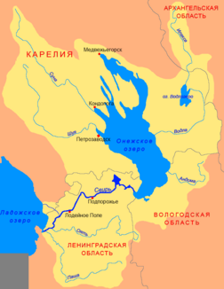
Course of the Wodla (Во́дла) in the catchment area of the Swir |
||
The Wodla ( Russian Во́дла ; Finnish Vodlajoki ) is a river in the southeast of the Republic of Karelia in northwestern Russia .
It arises at the confluence of Suchaja Wodla and Wama , the two outflows from Lake Wodlosero . The Wodla has a length of 149 km and a catchment area of 13,700 km². The mean discharge at the mouth is 130 m³ / s. The river flows south first, then changes direction west. It flows past the city of Pudosch and flows into Lake Onega . The outflow of its source rivers from the Wodlosero is regulated.
At least in the past, rafting was carried out on the Wodla .
Web links
- «Карелия» - туристический портал (russ.)

