
Woluwe-Saint-Pierre / Sint-Pieters-Woluwe
| Woluwe-Saint-Pierre Sint-Pieters-Woluwe |
|||
|---|---|---|---|

|

|
||
|
|||
| State : |
|
||
| Region : | Brussels capital | ||
| Province : | ("de-provincialized" since January 1st, 1995) | ||
| District : | Brussels capital | ||
| Coordinates : | 50 ° 50 ′ N , 4 ° 28 ′ E | ||
| Area : | 8.85 km² | ||
| Residents: | 41,824 (Jan 1, 2019) | ||
| Population density: | 4,726 inhabitants per km² | ||
| Post Code: | 1150 | ||
| Prefix: | 02 | ||
| Mayor: | Benoît Cerexhe ( MR ) | ||
Local government address : |
Avenue Charles Thielemans 93 1150 Bruxelles Charles Thielemanslaan 93 1150 Brussel |
||
| Website: | www.woluwe1150.be | ||

Woluwe-Saint-Pierre ( French ) or Sint-Pieters-Woluwe ( Dutch ) is one of 19 municipalities in the bilingual Brussels-Capital Region in Belgium . It has 41,824 inhabitants (January 1, 2019) on 8.9 square kilometers. The municipality is located in the elegant east of Brussels on the avenue de Tervuren / Tervurenlaan . It borders the municipalities of Auderghem / Oudergem , Etterbeek and Woluwe-Saint-Lambert / Sint-Lambrechts-Woluwe of the Brussels-Capital Region and the Flemish municipalities of Kraainem and Tervuren .
With Woluwepark , the municipality has one of the largest green spaces in all of Brussels. On avenue de Tervueren / Tervurenlaan is the Brussels Museum of Urban Transport, a collection of old trams. (Relatively) new trams, on the other hand, run on lines 39 and 44 through the municipality, which also has an underground station at the terminus of line 1 (Stokkel) . For the German-speaking population of the Brussels region, there are two churches, a Protestant and a Catholic , in this place, which is thus the cultural center of the Germans in Brussels.
Attractions
- The Palais Stoclet ( → Lage ) is one of the world's most famous Art Nouveau buildings .
- On the border to Etterbeek is the Collège Saint-Michel with adjoining church building ( → location )
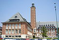
Parish hall of Woluwe-Saint-Pierre / Sint-Pieters-Woluwe

Émile Fabry's studio


Web links
- Website of the municipality of Woluwe-Saint-Pierre / Sint-Pieters-Woluwe (French, Dutch, English)
French-language names:
Anderlecht |
Auderghem |
Berchem-Sainte-Agathe |
Bruxelles-Ville |
Etterbeek |
Evere |
Forest |
Ganshoren |
Ixelles |
Jette |
Koekelberg |
Molenbeek-Saint-Jean |
Saint-Gilles |
Saint-Josse-ten-Noode |
Schaerbeek |
Uccle |
Watermael-Boitsfort |
Woluwe-Saint-Lambert |
Woluwe-Saint-Pierre
Dutch-language names:
Anderlecht |
City of Brussels |
Elsene |
Etterbeek |
Evere |
Ganshoren |
Jette |
Koekelberg |
Oudergem |
Schaarbeek |
Sint-Agatha-Berchem |
Sint-Gillis |
Sint-Jans-Molenbeek |
Sint-Joost-ten-Node |
Sint-Lambrechts-Woluwe |
Sint-Pieters-Woluwe |
Ukkel |
Vorst |
Watermaal-Bosvoorde