
Brussels Metro

The Brussels Metro ( French Métro de Bruxelles , Dutch Brusselse Metro ), together with the tram, forms the backbone of rail-based public transport in the Brussels-Capital Region , which, in addition to the urban area of Brussels, includes 18 other independent municipalities that form a coherent urban settlement area. The subwaydeveloped step by step from the tram network by laying tram lines in tunnels, which were then gradually converted to underground operation. The first underground line opened in 1976. The operator of the system, which currently has four lines, is the Société des Transports Intercommunaux de Bruxelles / Maatschappij voor het Intercommunaal Vervoer te Brussel , or STIB / MIVB for short.
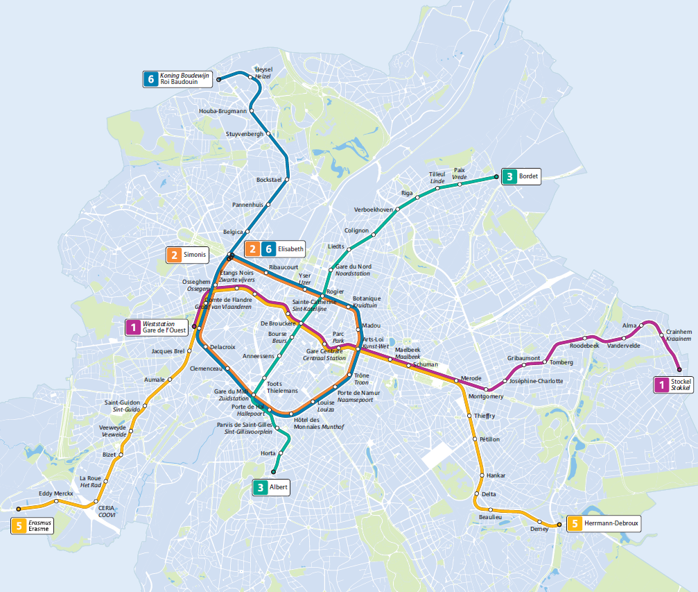
Line network

The Brussels metro system has 59 stations over a length of 38 kilometers and is operated regularly between 5 a.m. and 1 a.m. the following day. It comprises four underground lines, with two lines sharing longer sections of the route. The average station distance is 650 m, and the location of the stops was often retained when switching from tram to underground service. At peak times, the trains on the individual lines run at 5 to 6 minute intervals, the overlapping of the lines results in 2½ to 3 minute intervals on many sections of the route.
Lines 1 and 5 run together on the east-west route through the city center from Westbahnhof to Merode . At the eastern end of this route it splits into two branches, each of which is traveled by one of the two lines. Lines 2 and 6 run on the "Kleinen Ring" ( Petite Ceinture or Kleine Ring ). The network is supplemented by underground tram routes ( Premetro ), with the north-south route through the city center used by tram lines 3 and 4 being the most important.
Line overview
As of April 25, 2020
| line | colour | route | length | Travel time | Stations |
|---|---|---|---|---|---|
| 1 | purple | Gare de l'Ouest / Weststation - Beekkant - De Brouckère - Gare Centrale / Centraal Station - Arts-Loi / Kunst-Wet - Schuman - Merode - Montgomery - Tomberg - Alma - Stockel / Stokkel | 12.5 km | 26 min | 21st |
| 2 | orange | Simonis - Beekkant - Gare de l'Ouest / Weststation - Gare du Midi / Zuidstation - Louise / Louiza - Arts-Loi / Kunst-Wet - Rogier - Elisabeth | 10.3 km | 20 min | 19th |
| 5 | yellow | Erasme / Erasmus - CERIA / COOVI - Bizet - Saint-Guidon / Sint-Guido - Gare de l'Ouest / Weststation - Beekkant - De Brouckère - Gare Centrale / Centraal Station - Arts-Loi / Kunst-Wet - Schuman - Merode - Delta - Herrmann-Debroux | 17.3 km | 36 min | 28 |
| 6 | blue | Roi Baudouin / Koning Boudewijn - Heysel / Heizel - Bockstael - Simonis - Beekkant - Gare de l'Ouest / Weststation - Gare du Midi / Zuidstation - Louise / Louiza - Arts-Loi / Kunst-Wet - Rogier - Elisabeth | 15.5 km | 30 min | 26th |
Note: the stations Simonis and Elisabeth form a joint station complex with the possibility of changing between each other and to the Simonis S-Bahn station . Until November 5, 2013, both parts of the station were called “Simonis”, but were renamed because of the confusing signage for the ring line.
Stations
Most of the 59 metro stations are below street level. Some of them have a French and a Flemish (Dutch) name due to the bilingual nature of the city . Depending on how it was initially created, it can be determined whether a stop is located in a predominantly French or Flemish-speaking area. Of course, this does not apply to stations that are named after people (exception: Roi Baudouin / Koning Boudewijn , after King Baudouin ). The additions of geographical names such as rue / straat, place / plein (street, place)etc. are omitted in the station names, as is the case in many subway networks in French-speaking areas. Four subway stations are transfer stations within the metro system, at ten stations there are crossings to railway lines of the NMBS / SNCB including many lines of the S-Bahn Brussels . There are also numerous connections to the tram, including the Premetro underground tram lines and regular bus services.

There are side platforms as well as central platforms in the network, the platform length is always 120 m. The stations of line 2 Gare du Midi / Zuidstation and Rogier have both side platforms and central platforms, so that it is possible to get on and off on both sides of the door using the Spanish solution . At the Gare du Midi / Zuidstation stop, the platforms are separated by direction so that you can change to the Premetro lines on the north-south axis on the same platform. All stations are equipped with escalators , but newer and simply built stops have liftsand are therefore accessible for the disabled. However, in almost all stations the floor of the car is slightly higher than the edge of the platform. The shortest station distance is between Hankar and Delta at 304 m, and between Schuman and Merode the longest distance between two stations is 1,160 m.
The Brussels Metro is known for exhibiting works from various contemporary art movements in its stations. Painting, sculpture, photography and glass painting are represented, and a wide variety of materials were used for the works. The most famous work of art in the area of the metro system is the oversized wall painting “Notre Temps” (German “Our time”) by Roger Somville in 1976 in the Hankar station on Line 5, which with its shapes and intense colors fights for a fairer world in the thematized in both social and economic terms.
These works of art are so important that in 1990 the Ministry of Public Services set up the independent art commission for the public transport network CAID / ACVI, whose area of responsibility is limited to the recommendation and approval of artistic works for all means of transport in the greater Brussels area. This commission selects the works of art in such a way that they correspond to the broad consensus of values in society.
As part of the barrier-free access , all underground stations are gradually being equipped with elevators . While there were only 16 stations in 2006, 53 of 69 metro and premetro stations (around 77%) can be reached without steps at the beginning of 2020. For all other stations, elevators are currently under construction or planning. In addition, the STIB / MIVB offers a free assistance service daily from 7 a.m. to 10 p.m. for people who need assistance when entering / driving the train with a wheelchair.
story

Early planning
The first plans to build a metro in Brussels were made as early as 1892. During the first half of the 20th century, various other networks were designed, which, however, were not supported by either the population or the city administration. For example, in 1925, the aircraft and railroad construction company Dyle & Bacalan Corporation hired a three-line metro project.
The first line was to open up the city center in a north-south direction below the boulevards. The aim was to use the infrastructure that has remained unused since the diversion of the Senne River . The original concepts provided for possible route extensions at each terminus. The second line was to connect the areas east and west of the city center and offer transfer options to the first line in the city center. The third line was only listed as optional in the plans, whereas the first two should be built immediately according to the plans.
Construction of underground tram lines
After the end of the Second World War , voices were raised to move some tram routes underground, thereby making more space available on the streets for the ever-growing motor vehicle traffic. The speed of the trams decreased continuously due to traffic jams, so it was decided, if possible, to run the routes on their own track and the lines in the city center through tunnels. For this purpose, the Société des Transports Intercommunaux des Bruxelles / Maatschappij voor het Intercommunaal Vervoer te Brussel (STIB / MIVB) was founded in 1954, which operates the tram, bus and subway network in Brussels.
In 1957 the first tunnel was opened near the congested Place de la Constitution / Grondwetplein between the Gare du Midi / Zuidstation and today's Lemonnier station, although it did not yet include an underground station. The tunnel was carried out at the same time as other measures in connection with the 1958 World Exhibition in Brussels . This so-called “Grondwettunnel / Tunnel de la Constitution” is still used as part of the north-south axis of today's tram network between Gare du Nord / Noordstation and Albert .
In 1963 the Belgian government set up working groups to deal with the traffic problems in Belgium's five largest cities, Brussels, Antwerp , Liège , Ghent and Charleroito tackle. Funding was approved for the implementation of projects, with half of the budget being available for the capital Brussels, a quarter for the Flemish cities of Antwerp and Ghent and a quarter for the Walloon cities of Liège and Charleroi. According to a study from this year that looked at the development of public transport in the urban region, the future traffic problems would affect not only the inner-city area, but also the outskirts. The high number of expected passengers led to the decision of the municipal council and the Belgian government to develop a conventional metro system for Brussels. The planned metro lines should replace the most popular tram lines. However, the financial means were not sufficient to create full-fledged metro lines at short notice. In addition, a few years earlier, the STIB / MIVB procured new tram cars in order to meet the expected influx of visitors for theFacing Expo 1958 . Therefore, it was decided to build tunnels and initially let tram cars pass through them. However, these tunnels were designed in such a way that they could later be used for full-fledged metro operations. In the medium term, it should be possible to gradually expand the tunnel sections and convert these systems to underground operation. This concept is called Premetro , and numerous cities in the Federal Republic of Germany that operate under the name of Stadtbahn also envisaged similar projects .
The planned route network from 1963 comprised an east-west line, which splits east and west of the city center into two branches leading north and south, a north-south line between the stations Gare du Nord / Noordstation and Gare du Midi / Zuidstation , a so-called "Small Ring" and a "Big Ring".
In 1965, work began on the Schuman roundabout for the first so-called Premetro tunnel (French Prémétro ), which is now part of the metro network. This tunnel was opened for the Brussels tram between the Schuman and De Brouckère stops on December 20, 1969 . This is now used by lines 1 and 5. On December 20, 1970, the second tram tunnel was opened between Madou and Porte de Namur / Naamsepoort , and that on August 18, 1974 at the northern end by two more stations to Rogierwas extended. This route is part of the “Little Ring” and is currently used by metro lines 2 and 6 after further extensions.
The metro plans from 1969
In 1969, when the first Premetro line went into operation, a plan appeared that provided for the construction of five full-fledged metro lines that would be used by trams in the first phase and should be completed within 30 years.

The following routes were presented:
- Line 1 should be an east-west line that branches into two arms in the east. The western part of the route should run below the Chaussée de Gand / Gentsesteenweg to the regional border near the Brussels ring road. The eastern and inner-city sections were actually created later, they are now used by lines 1 and 5. In the station Osseghem / Ossegem there is an additional floor for this line, which was never used.
- Line 2 should represent half a ring line around the east of the city center, which would continue in the northwest to Heysel / Heizel and in the southwest to Anderlecht . The route to Heysel / Heizel now serves line 6, the last stations of the section to Anderlecht are stations of today's line 5. The planned section between Simonis and Gare du Midi / Zuidstation is also in operation and is served by lines 2 and 6 . It exists today with the Hôtel des Monnaies / Munthofanother station that did not exist in the planning at the time. The first section of this line opened in 1970, at that time still as a premetro line.
- According to the plans, line 3 should be a north-south line through the city center, leading in the south to Uccle / Ukkel and in the north via Schaarbeek / Schaerbeek to Evere . The section of the route between Gare du Nord / Noordstation and Albert is now in premetro operation.
- Line 4 was to be a short line with only six stations, coming from the southeast of Ixelles / Elsene towards the city center. For this line, shell structures of additional platforms have been built at the Parc / Park , Botanique / Kruidtuin and Louise / Louiza transfer stations, which have not yet been used.
- Line 5 should drive the so-called "Big Ring" from Gare du Nord / Noordstation to Gare du Midi / Zuidstation over the east of the city. A small part of this line has actually been built and is served by trams between Diamant and Boileau . Even before the first fully-fledged metro lines were inaugurated, a new plan appeared that included a large number of changes.
The Premetro construction is progressing
By 1976, two more longer tunnels were built, but they are still in operation as tram tunnels (Premetro) to this day. These are parts of the projected "Great Ring" in the east of the city, which was inaugurated as a tunnel section with the only station Diamant on May 2, 1975 and was extended south to Boileau on January 30, 1975 , as well as the North-South axis. Since the extension of the Constitution / Grondwettunnel tunnel without a train station from Lemonnier to Rogier, it has tunnelled the entire inner city area.
The 1975 metro plans
The second plan from 1975 presented an even more ambitious network, with the planned lines extending to the outlying communities outside the city limits such as B. to Tervuren , Dilbeek , Linkebeek and the airport . This plan also assumed a premetro stage; Since the mid-1980s, all lines should be converted to metro operation so that they could be extended further.
The plans introduced today's line 1, which also splits into two branches in the west. In addition to the metro network, a light rail network was planned to open up more sparsely populated areas and to transport passengers to and from the metro stations. Another important part of the plan was the creation of P + R facilities on the outskirts. The routes outside the city center were only given approximately so that the exact routes could later be determined in accordance with the development of the urban area.
The network should have been complete by the year 2000, but the report also indicated that this schedule is heavily dependent on financial possibilities. Ultimately, the project was not implemented that way.
Conversion to subway operation
The route between Schuman and De Brouckère was switched from Premetro to Metro operation on September 20, 1976. Since then, the greater Brussels area has had a fully-fledged metro. The change essentially comprised increasing the height of the platform above the upper edge of the rails from 50 to 100 cm, extending the 30 m long platforms to 120 m, removing the overhead lines for the corresponding tunnel routes and installing power rails . Since the tunnel dimensions and platform lengths already met the underground standards when the Premetro lines were built, the conversion costs were kept within limits. During this and subsequent conversion work, aRail replacement services offered by buses. This first metro network in Brussels included the two lines 1A and 1B, which served the section between De Brouckère and Merode in the Y network . After Merode , line 1A ran south-east to Beaulieu , 1B ran north-east to Tomberg .
With the introduction of the metro in 1976, the logo for it was also introduced. In response to an invitation to tender, a jury selected a pre-selection of five logos from the entries, including one with a mole. Then about 1200 residents of five Belgian cities were interviewed about the fact that the symbol was to be introduced across Belgium for subways. This decision and the prize money of 100,000 Belgian francs was won by Jean-Paul Edmonds-Alt (1928–2014), a sculptor from Brussels. The original logo still had an arrow at the lower right corner of the "M", which pointed to the lower right, but was later left out as it led to confusion.
Network expansions

In the years that followed, the subway was continuously extended. The intermediate stage of a Premetro was dispensed with, as this would not be of any particular benefit when extending the network. Extensions were made to the trunk, which was served jointly by 1A and 1B, heading west in 1977 to Sainte-Catherine / Sint-Katelijne and in 1981 to Beekkant . Further extensions on the eastern branches followed in 1977 and 1982 to Demey and Alma , respectively , until 1982 with the opening of the sections from Beekkant to Saint-Guidon / Sint-Guido and to Bockstaeltwo branches are also served in the west of the trunk line. The branch leading to the north was occupied by the 1A, whereas the 1B operated on the route running south from Beekkant. Trains on line 1A had to change direction when leaving Beekkant station in order to switch to the inner-city trunk or north-east branch.

Further extensions followed in several steps, including the Bizet train station, which was partly built under water by 1992 due to unfavorable geological conditions. The last extension on the 1A took place in 1998, when the Roi Baudouin / Koning Boudewijn station, originally planned as Amandelbomen, was inaugurated and at the same time the previous terminal Heysel / Heizel was moved underground and the temporary station building of this station was expanded to prevent capacity bottlenecks at major events . In 2003 line 1B was extended for the last time, after Erasme / Erasmus .
In the meantime, the second tunnel between Madou and Porte de Namur initially remained as a premetro route. The 7½ km long route was only adapted to underground operation in 1988 and run as line 2, which was to bypass the Brussels city center Pentagone in a ring to be completed later. This underground line has been extended several times. During the construction of the extension of the Premetro tunnel until 1988 in both directions to Gare du Midi / Zuidstation and to today's endpoint Elisabeth (at that time Simonis) one came across between Hôtel des Monnaies / Munthof and Porte de Hal / Hallepoortat a depth of more than ten meters on masonry from the 18th century with a thickness of three to four meters. With the inauguration of the network expansion work began on the continuation of the line with one station to Clemenceau in Anderlecht, the difficulty of which was to drive under a factory building over a distance of around 70 meters with the help of supporting beams. In 2006 the extension to Delacroix took place , on April 4, 2009 the last section to the Westbahnhof was opened.
Situation in Beekkant until April 2009

Due to the management of the former line 1A, whose trains changed direction in the Beekkant station until April 2009 ( see animation in the picture on the right ), the area of lines 2 and 6 between the underground stations Gare du Midi / Zuidstation and Roi Baudoin / Koning Boudewijn and Simonis (Leopold II) operated in left-hand traffic . Therefore, during the construction of line 2, in order to be able to introduce it accordingly into the route of line 1A (today's line 6), an underground transfer structure was created between the stations Gare du Midi / Zuidstation and Clemenceau , which leads the trains to the respective left track .
Restructuring of the metro network
After this ring closure, the Brussels metro network was restructured. Line 2 now runs the ring from Simonis to Elisabeth, but continuous ring traffic is not possible because the different tracks of the Simonis / Elisabeth station cross on different floors. Line 6 also runs on the Ring and then on to Roi Baudouin / Koning Boudewijn . The former line 1A (now 5) took over the route Beekkant - Erasmus from the former line 1B (now 1). The new line 1 now ends at Westbahnhof. As a result, the time-consuming change of direction of trains on line 1A in the Beekkant station is a thing of the past.
Opening dates

The following table contains the opening dates of the individual route sections in chronological order. All Premetro sections are also listed; those that were later converted to metro operation are therefore listed twice. Where no line is given for line today , it is still a Premetro operation with tram cars.
| date | Lines | route | |
|---|---|---|---|
| at opening |
today | ||
| December 17, 1969 | Premetro | 1, 5 | De Brouckère - Schuman |
| December 20, 1970 | Premetro | 2, 6 | Madou - Porte de Namur / Naamsepoort |
| May 2, 1972 | Premetro | - | diamond |
| Aug 18, 1974 | Premetro | 2, 6 | Madou - Rogier |
| Jan. 30, 1975 | Premetro | - | Diamond - Beaulieu |
| Sep 20 1976 | 1A, 1B | 1, 5 | De Brouckère - Merode |
| Sep 20 1976 | 1A | 5 | Merode - Beaulieu |
| Sep 20 1976 | 1B | 1 | Merode - Tomberg |
| Oct. 4, 1976 | Premetro | - | Lemonnier - Gare du Nord / Noordstation |
| Apr 13, 1977 | 1A, 1B | 1, 5 | De Brouckère - Sainte-Catherine / Sint-Katelijne |
| 17th June 1977 | 1A | 5 | Beaulieu - Demey |
| May 8, 1981 | 1A, 1B | 1, 5 | Sainte-Catherine / Sint-Katelijne - Beekkant |
| May 7, 1982 | 1B | 1 | Tomberg - Alma |
| Oct 6, 1982 | 1A | 2, 6 | Beekkant - Bockstael |
| Oct 6, 1982 | 1B | 1, 5 | Beekkant - Saint-Guidon / Sint-Guido |
| March 23, 1985 | 1A | 5 | Demey - Herrmann-Debroux |
| May 10, 1985 | 1A | 2, 6 | Bockstael - Heysel / Heizel |
| 5th July 1985 | 1B | 5 | Saint-Guidon / Sint-Guido - Veeweide / Veeweyde |
| Aug 19, 1985 | Premetro | 2, 6 | Porte de Namur / Naamsepoort - Louise / Louiza |
| June 23, 1986 | Premetro | 2, 6 | Simonis |
| Aug 31, 1988 | 1B | 1 | Alma - Stockel / Stokkel |
| Oct 2, 1988 | 2 | 2, 6 | Elisabeth - Gare du Midi / Zuidstation |
| Jan. 10, 1992 | 1B | 5 | Veeweyde / Veeweide - Bizet |
| June 18, 1993 | 2 | 2, 6 | Gare du Midi / Zuidstation - Clemenceau |
| Dec 3, 1993 | Premetro | - | Gare du Midi / Zuidstation - Albert |
| Aug 25, 1998 | 1A | 6 | Heysel / Heizel - Roi Baudouin / Koning Boudewijn |
| Sep 15 2003 | 1B | 5 | Bizet - Erasme / Erasmus |
| 4th Sep 2006 | 2 | 2, 6 | Clemenceau - Delacroix |
| Apr 4, 2009 | 2, 6 | Delacroix - Gare de l'Ouest / Weststation also changeover of the line network |
|
Incidents
Terrorist attacks on March 22, 2016
In the terrorist attacks on March 22, 2016, there were two explosions at Brussels-Zaventem Airport and another detonation in a train approaching the Maelbeek / Maalbeek metro station (lines 1 and 5). A total of 32 people were killed in this attack, most of them in the subway. The station was closed for several weeks.
Planning

Of the numerous projects that are being discussed, only metro line 3 "Metro Nord" is in the advanced planning stage. After planning three line variants, the decision was made in 2014 for a line from the North Station with the intermediate stops Liedts , Colignon , Verboekhoven , Riga , Tilleul / Linde and Paix / Vrede to the Bordet station. In addition, the previous Premetro line will be rebuilt between the North Station and Albert , with a new tunnel with a Toots Thielemans station between Anneessens and the South Station (originally planned asConstitution / Grondwet ), as today's tram tunnel is to continue to exist in this section. Albert station will also be rebuilt so that it can serve as the terminus of the metro and tram lines 4, 7 and 51. The metro replaces tram line 55 (Rogier - Da Vinci), which is being discontinued; the tram lines 3, 4 and 51, however, are divided into two parts. The MIVB / STIB hopes to have obtained all permits by 2018 and is assuming a construction phase of four years. In 2019, the new government of the Brussels region confirmed the project, with the opening of the Albert - Nordbahnhof section (i.e. the existing Premetro section) now expected in 2024, and the extension to Bordet in 2030.
vehicles
Since the first changeover from Premetro routes to subway operation in 1976, the four different vehicle series M90 , M70 , M32 and Bombardier / Alstom have been used, all of which are still in operation. The trains travel on a track network with standard gauge (1435 mm gauge) and are supplied with direct current with a voltage of 900 volts by means of a busbar coated on the underside . A fifth row of vehicles is currently under construction.


Originally in 1976, the M90 series consisted of 90 vehicles with a length of 18 meters each. 60 of these were delivered by La Brugeoise et Nivelles (BN) and ACEC and 30 by CFC and ACEC. These vehicles have a driver's cab so that these vehicles drive coupled together as a double multiple unit under the type designation U2 . Each of these vehicles has four doors on both sides. Between the cars there is only an operating passage equipped with windows to allow a view through the train. The network expansion in 1980 came under the name of the M70 seriesa further 70 cars manufactured by BN / ACEC were added, so that the car fleet at that time comprised a total of 160 cars or 80 double railcars.
With the increase in the number of passengers, which was particularly associated with the opening of Line 2 in 1988, the vehicle fleet reached its capacity limits. The need arose again to increase the number of vehicles. In 1989, BN / ACEC received an order for 32 motorized intermediate cars without a driver's cab; these M32 series cars were delivered until 1993. With the help of these intermediate cars, three-car formations, known as U3s , could be formed by combining them with a double multiple unit . In 1999 another ten two-car units and twelve three-car formations of the series Bombardier / Alstom were addeddelivered, whereby a total of 102 train sets could be used. Two double railcars can be coupled to form a four-car set U4 or a two-car and three-car unit can form a five-car train with the designation U5 , which is 90 meters long and has the maximum length that the Allow platform lengths.
Most trains are equipped with an automatic audio-visual station announcement. In the middle of the vehicles there are electronic displays that announce the next stop, a woman's voice gives the name and possible transfer options.
In February 2004, 15 new vehicles were ordered from the Spanish company Construcciones y Auxiliar de Ferrocarriles , which are to be delivered between June 2006 and January 2008. At 94 m, the six-car trains are four meters longer than a five-car U5 set and can be walked on across the entire length of the vehicle. This gives passengers greater freedom of movement and no passenger capacities are lost through the space between the trains. The maximum speed of this train, which is run under the type number B2, M6 or the name BOA , is 80 kilometers per hour. The trains, with 18 doors on each side, can carry 774 passengers, significantly more than the capacity of theU5 formations of 695 passengers. By exercising an option, the number increased by six vehicles to 21 underground trains.
A further development of the BOA trains from CAF has been ordered. From 2020, 43 M7 trains will be delivered with a modified design. The 94 m long and 2.7 m wide six-car trains can carry between 742 and 758 passengers and are intended for use on the new line 3. The vehicles are prepared for driverless operation.
Operating facilities
Operations control center
The central operations control center of the metro network is located at the Parc / Park station . Among other things, this controls the largely automatic operational management with signal circuits, switches, etc. via a central computer, the power supply of the busbars through the numerous rectifier plants , the situation in the train stations by camera, and intervenes in operations in the event of malfunctions. The safety concept includes safety systems such as automatic train control and a self-blocking systemwith traffic lights. The control of the trains during departure, acceleration and braking is computer-aided, with the trains being registered when they enter a station and the data being transmitted to the central computer. In this way, the central computer controls the target displays associated with it in the stations and transmits the automatic station announcements. The control center can contact the train driver by radio , and information from the train driver or the operations control center can be transmitted to the passengers via a microphone in the vehicles.
Depot and workshop
The Delta depot with an attached workshop is located between the Delta and Beaulieu stations on Line 5. The repair and maintenance work on the trains takes place in the two-storey, 15,700 m² workshop. The busbars end just before the workshop to ensure work safety. Diesel or battery locomotives maneuver the trains within the workshop facilities and the site, and depending on the siding, a mobile conductor rail or a flexible power line is available for moving vehicles out or in. The storage hall covers an area of 13,000 m², the tracks around 88,000 m².
In 2009, another depot named Jacques Brel was opened, which is responsible for lines 2 and 6 and has a total area of 15,000 m² (of which the wagon hall 9,100 m² and the workshop 5,200 m²).
Unused infrastructure
Due to the changing planning and financing problems, some structures of the Brussels Metro were never put into operation; all objects listed here were built on behalf of the STIB / MIVB. These facilities are known in the Belgian vernacular as "Grands Travaux Inutiles" (large, useless structures).
The Sainctelette train station (lines 2 and 6), completely completed in 1988, never went into operation because it is too close to the Ribaucourt and Yser / IJzer underground stations .
The Simonis train station (lines 2 and 6) has a three-storey underground car park over 780 meters long under the Elisabethpark. Originally, the underground car park was supposed to be accessible via a tunnel from Simonis , but the facility was not completed for cost reasons. There is no entry and exit, the shell can be reached via an emergency exit in the park and a connecting door in Simonis station .
Under the train stationPorte de Namur / Naamsepoort (on lines 2 and 6) is the shell of a large NBC protective bunker for civilians.
In the following stations, there are additional platforms in the shell (i.e. without tracks or other equipment) for subway plans that have never been implemented: Parc / Park , Louise / Louiza , Botanique / Kruidtuin , Osseghem / Ossegem ( see above ), as well as Anneessens and Saint -Guidon / Sint-Guido.
Brussels pneumatic tube
At the end of the 1960s, special pipes with a diameter of 50 cm were installed along the tunnels on some routes. These connect the mail sorting centers “Brussels X”, “Brussels 1”, “Brussels 4” and “Office des Checks Postaux”. Due to pressure from the postal unions, who feared job losses, the pneumatic tube system was never put into operation.
Brussels police shooting range
As part of the track work near the Rogier train station, an underground shooting range was built by STIB / MIVB on behalf of the City of Brussels. Because of the rising costs of the construction project, the city of Brussels refused to provide further funding; so it remained a shell.
See also
literature
- Walter J. Hinkel, Karlreiber, Gerhard Valenta, Helmut Liebsch: U-Bahn - yesterday-today-tomorrow - from 1863 to 2010 . NJ Schmid Verlagsgesellschaft, Vienna 2004, ISBN 3-900607-44-3
- Daniel Bennett: Metro. The history of the subway . Transpress, Stuttgart 2005, ISBN 3-613-71262-8
- Daniel Riechers: Metros in Europe . Transpress, Stuttgart 1996, ISBN 3-344-71049-4
- Jean-Claude Defossé: Le petit guide des Grands Travaux Inutiles . Paul Legrain & RTBF Édition, Brussels, May 1990 (French)
Web links
- Societé des Transports Intercommunaux des Bruxelles (STIB / MIVB; operator of the Brussels Metro)
- Information about the Brussels Metro on urbanrail.net (private)
- Photos of the Brussels metro on metro-de-bruxelles.blogspot.com (private)
- Track plan of the metro and tram on cartometro.com (private), accessed on April 25, 2020
Individual evidence
- ↑ a b times right, sometimes left in: Tram Magazin 1/2004, p. 48 ff.
- ^ STIB / MIVB: Art in Brussels begins in the metro [translated title]. September 2012, accessed April 25, 2020. French PDF , Dutch PDF .
- ↑ Bennett, Daniel: Metro. The history of the subway , Transpress, Stuttgart 2005, p. 86, ISBN 3-613-71262-8
- ↑ The accessibility des stations de métro à Bruxelles. Autonomia, February 1, 2018, accessed April 25, 2020 (French).
- ↑ Accessibility des stations de métro. Bruxelles Mobilité - Service Public Régional de Bruxelles / Brussel Mobiliteit - Gewestelijke Overheidsdienst Brussel, accessed on April 25, 2020 (French).
- ↑ Reseau du Metro de Bruxelles - Programs d'équipement pour les personnes à mobilité réduite / Brussels Metronet - Uitrustingsprogramma voor de people with perfect mobility. (PDF; 82.3 KB) Bruxelles Mobilité - Service Public Régional de Bruxelles / Brussel Mobiliteit - Gewestelijke Overheidsdienst Brussel, January 7, 2020, accessed on April 25, 2020 (French, Dutch).
- ↑ Accessibility. STIB / MIVB, accessed on April 25, 2020 (French).
- ↑ Steven Van Garsse: Opmerkelijk: Een 'M' zo oud zelf as de Metro . In: Brussel Deze Week edition 1438 of August 21, 2014, p. 2
- ↑ Planning of the MIVB / STIB 2009 (Dutch)
- ↑ Archived copy ( memento of March 25, 2016 in the Internet Archive ), accessed on March 24, 2016
- ↑ Bruxelles: le tracé du métro Nord est connu (carte). Le Soir, May 8, 2014, accessed April 25, 2020 (French).
- ↑ Metro 3. Bruxelles Mobilité - Public Service Régional de Bruxelles / Brussel Mobiliteit - Gewestelijke Overheidsdienst Brussel, accessed on 25 April 2020 (French, Dutch).
- ↑ Le nouveau gouvernement bruxellois confirme la ligne de métro 3. In: Metro 3. Bruxelles Mobilité - Service Public Régional de Bruxelles / Brussel Mobiliteit - Gewestelijke Overheidsdienst Brussel, July 18, 2019, accessed on April 25, 2020 (French).
- ↑ MIVB / STIB route network map (PNG, 482 kB)
- ↑ Robert Schwandl: TRAM ATLAS Benelux . Robert Schwandl Verlag, Berlin.
- ↑ Keith Barrow: CAF completes first M7 train. In: railjournal. IRJ, March 26, 2019, accessed on October 21, 2020 .
- ^ Site Jacques Brel. (PDF; 1 MB) STIB / MIVB, 2008, accessed on April 25, 2020 (French).
- ^ Franklin Jarrier: Carte détaillée du réseau de métro et tramways de Bruxelles. In: cartometro.com. December 19, 2019, accessed April 25, 2020 (French).