
Woogsee
| Woogsee | ||
|---|---|---|

|
||
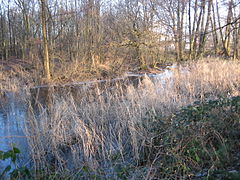
| View from the north to the south bank of the Woogsee | ||
| Geographical location | Baden-Württemberg | |
| Tributaries | Woogseegraben, Obere Wiesen Graben | |
| Drain | Woogseegraben | |
| Data | ||
| Coordinates | 48 ° 51 '26 " N , 8 ° 14' 3.3" E | |
|
||
| Altitude above sea level | 115 m above sea level NN | |
| surface | 0.4 ha | |
| length | 250 m | |
| width | 15 m | |
| Middle deep | 2 m | |

The Woogsee is a small body of water in the east of Rastatt in Baden-Württemberg. It is approx. 250 m long, up to 15 m wide, has an elongated shape and extends roughly from north to south. The lake was designated as a natural monument on November 14, 1939 .
The lake is located north of the Murg on the western edge of the so-called Kinzig-Murg-Rinne , a depression on the edge of the Upper Rhine Plain . After the last Ice Age, rivers from the Black Forest ran north in the depression before they flowed into the Rhine . Later, more direct rivers to the Rhine emerged. Local literature sees the Woogsee partly as a relic of the Landsee , which stretched south of the Murg between Niederbühl , Haueneberstein , Sandweier and Oos . No evidence is known for this. In the biotope mapping , the Woogsee is described as a gorge and “[n] near-natural remainder of an old channel of the Kinzig-Murg channel”.
In the 1960s and 1970s, the Woogsee was used as a rubbish dump and its banks as a commercial raspberry and blackberry plantation due to its location directly on an industrial area. Huts were also illegally built before the lake was rehabilitated in the 1980s. Among other things, the city of Rastatt had around 500 cubic meters of mud dredged so that it could reach its original depth of an average of 2 meters.
An overview of nature conservation in the Rastatt district described the Woogsee in 2011 as the "most depressing example of a wetland of the old Kinzig-Murg-Rinne that is now completely surrounded by building land". The lake is fighting for survival against the harmful influences of the neighboring industrial area, against sewage, noise and isolation from the open landscape. In 1964, the Woogsee was still described as a natural idyll with the only disadvantage that cattle from the adjacent pastures use the lake as drinking water and thereby damage the vegetation on the banks.
The north bank

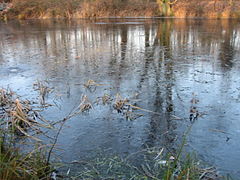
The lake in breadth
In the middle of the lake

View from south to north

The southern end of the lake


literature
- Rainer Gingelmaier: The Woogsee in Rastatt. In: Landkreis Rastatt (ed.): Heimatbuch 1988. Rastatt 1988, ISBN 3-925553-03-7 , pp. 71-76.
Web links
Individual evidence
- ↑ Cross profile , generated from the digital terrain model of the online map server of the State Agency for the Environment Baden-Württemberg (LUBW), see the web links.
- ↑ Layer standing water of the map services of the LUBW, see the web links
- ^ W. Schweinfurth, E. Reinhard, O. Rothenberg: Rastatt. Natural space and settlement. In: Landesarchivdirektion Baden-Württemberg (ed.): The district of Rastatt. Volume 2, Thorbecke, Stuttgart 2002, ISBN 3-7995-1364-7 , pp. 341-367, here p. 347.
- ↑ Forest biotope mapping, survey form FND "Woogsee" O Rastatt (No. 271152165494). (Accessed March 16, 2020)
- ^ Martin Klatt: Nature conservation in the district. A critical overview. In: Jürgen Bäuerle (Ed.) Heimatbuch 1961–2011: (= Heimatbuch Landkreis Rastatt , Volume 50) Regionalkultur, Ubstadt-Weiher 2011, ISBN 978-3-89735-684-9 , pp. 201–214, here p. 203 .
- ^ Alfred Schlotthauer: Am Woogsee. In: About the Rhine and Murg. Home register of the district of Rastatt. Volume 4, Rastatt 1964, pp. 172-178.