Xangongo
| Xangongo | ||
|---|---|---|
|
|
||
| Coordinates | 16 ° 45 ′ S , 14 ° 58 ′ E | |
| Basic data | ||
| Country | Angola | |
| Cunene | ||
| Município | Ombadja | |
| ISO 3166-2 | AO-CNN | |
| local community | Xangongo | |
| Residents | 5000 | |
| politics | ||
| mayor | Metódio Halukeinge | |
Xangongo is a place in the southwest of Angola . The city is located about 850 km south of Luanda and about 150 km north of the border with Namibia . The closest major city is Lubango , about 150 km away.
history
Under Portuguese colonial rule , the place had the Portuguese name of Vila Roçadas. It has had its current name since Angola's independence in 1975.
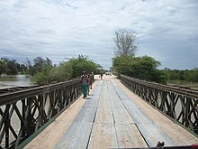
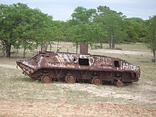
Xangongo gained importance in the Angolan Civil War (1975-2002) mainly due to its location on the most important north-south road connection and a bridge over the Cunene River . This was repeatedly the target of attacks by the civil war parties. The importance of this place and the bridge was so great that Xangongo, the neighboring village of Piu-Piu and the bridge were secured by more than 120,000 anti-tank and rifle mines as well as an artillery battalion and an anti-tank battalion. The bridge was almost destroyed in the end and was made passable again as a makeshift with the help of armored bridge parts.
The German Emergency Doctors Committee Cap Anamur started in 1992 as the first aid organization with mine clearance and ordnance disposal in the region. When the civil war flared up again, the crew was in a dire situation, and there were even casualties from the demining. Shortly after this debacle, Cap Anamur withdrew from mine clearance and handed over the camp near Xangongo to the aid organization Stiftung Sankt Barbara Deutschland . Since this organization also withdrew from Angola, the camp has been used and maintained by the People Against Mines Foundation .
In the course of the extensive reconstruction efforts of the Angolan government after the end of the civil war in 2002, numerous roads in Xangongo were renewed and paved, schools and health facilities were renewed, and the water and electricity supply improved. At the beginning of 2014, the first section, considered difficult, was paved, the 51 km long link of the road from Xangongo to Calongo ( Cuvelai district ).
In 2013, Xangongo hosted the Republic of Angola's central celebration of the annual commemoration of the beginning of the Angolan War of Independence on February 4, 1961.
administration
Xangongo is the seat of a municipality of the same name (Comuna) in the district ( Município ) of Ombadja , in the province of Cunene . The population of the place is estimated at around 5000.
traffic
The city has the airport Vila Roçadas / Xangongo ( IATA airport code : XGN; ICAO code : FNXA). It was established in 1988 as an air force base by Cuban units who fought alongside the Angolan government forces against the invading South African armies.
Web links
Individual evidence
- ↑ a b c Article of February 3, 2013 by the Angolan state news agency ANGOP , accessed on April 12, 2014
- ↑ MCC harvest AT mines in Xangongo. (No longer available online.) People Against Mines, 2004, archived from the original on May 9, 2011 ; accessed on May 17, 2011 (English).
- ↑ Article of January 27, 2014 by the state news agency ANGOP, accessed on April 12, 2014
- ↑ Entry from Xangongo Airport ( Memento from April 13, 2014 in the Internet Archive ) on www.flightaz.com, accessed on April 12, 2014
- ↑ Xangongo Airport on aerobaticsweb.org, accessed April 12, 2014


