Yangiyer
|
Yangiyer Annier |
||
| Basic data | ||
|---|---|---|
| State : |
|
|
| Province: | Sirdaryo | |
| Coordinates : | 40 ° 16 ′ N , 68 ° 49 ′ E | |
|
|
||
| Height : | 315 m | |
| Residents : | 37,984 (2012) | |
| Telephone code : | (+998) 36737 | |
| License plate : | 12 | |
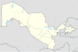
Yangiyer ( Cyrillic Янгиер ; Russian Янгиер Jangijer ) is a city in the Uzbek province of Sirdaryo , located about 25 km south of the provincial capital Guliston at 315 m above sea level in the steppe Mirzacho'l . Yangiyer is an independent city. According to the 1989 population census, Yangiyer had 28,600 inhabitants at the time, according to a calculation for 2012 the population is 37,984.
Yangiyer was founded in 1957 as part of a development plan for the steppe areas. In addition to some industrial plants and a railway station, Yangiyer also houses a museum that documents the development of the Mirzacho'l steppe.
With an annual average temperature of 15.1 ° C, the annual precipitation in Yangiyer amounts to 257 mm.
sons and daughters of the town
- Anastassija Yermakowa (* 2000), Kazakh pole vaulter
Individual evidence
- ↑ Page no longer available , search in web archives: bevoelkerungsstatistik.de
- ↑ Great Soviet Encyclopedia
- ^ Gustave Gintzburger, CIRAD: International Center for Agricultural Research in the Dry Areas . Editions Quae, 2003. ISBN 9782876145559
