Yarbutenda
| Yarbutenda | ||
|---|---|---|
|
Coordinates: 13 ° 26 ' N , 13 ° 53' W |
||
| Region: | Upper River | |
| District: | Cantora | |
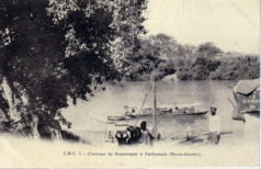
| Yarbutenda, early 20th century | ||
Yarbutenda (write variant: Yarbu Tenda or French Yarboutenda ) of the 19th century was to end Fattatenda a French (even commercial establishment Faktorei called) of the Compagnie Française d'Afrique Occidentale in the West African country Gambia .
The site is now in the Upper River Region in the Kantora district . Yarbutenda, about four kilometers from Koina and 42 kilometers from Basse Santa Su , was on the Gambia River and had a dock there. The tidal range of the Atlantic Ocean is still noticeable up to here, about 500 river kilometers inland.
In the history of the Gambia , the border region and the trading post were always controversial, so Yarbutenda was handed over to the French with the Treaty of Utrecht (1713) from the Kingdom of Great Britain and later, in 1904, again.
Culture and sights
The abandoned trading house remains from the old settlement of Yarbutenda.
Individual evidence
- ^ Meyers Konversations-Lexikon
- ↑ The Atlas of the Gambia (English) by Dr. Malanding S. Jaiteh, map , accessed May 2010
- ↑ PMEDP The economic and social contribution of fisheries to the economic development of The Gambia PDF file
- ↑ Allen Meagher, Andrew Samuel, Baba Ceesay, National Council for the Arts and Culture (Gambia) et al .: Historic sites of The Gambia: an official guide to the monuments and sites of The Gambia. National Council for the Arts and Culture, Banjul, The Gambia 1998, ISBN 9983-80-011-014

