
Yeğenli
| Yeğenli | ||||
|
||||
| Basic data | ||||
|---|---|---|---|---|
| Province (il) : | Mersin | |||
| District ( ilçe ) : | Silifke | |||
| Coordinates : | 36 ° 36 ' N , 34 ° 0' E | |||
| Height : | 1087 m | |||
| Residents : | 519 (2019) | |||
| Telephone code : | (+90) 324 | |||
| Postal code : | 33940 | |||
| License plate : | 33 | |||
| Structure and administration (as of 2019) | ||||
| Muhtar : | Musa Taş | |||


Yeğenli is a hamlet in the Silifke district of the Turkish province of Mersin . Until 2012 Yeğenli was a village with 696 inhabitants at last and then became part of the district center Silifke after a regional reform . The place is about 20 kilometers north of the center of Silifke and 60 kilometers southwest of the provincial capital Mersin . It is connected by country roads to Sömek, seven kilometers to the east, and to Uzuncaburç , the ancient Olba , just as far away , in the west. In ancient times the place belonged to the Rough Cilicia .
Yeğenli Tower
About two kilometers southwest of Yeğenli, 120 meters north of the road to Uzuncaburç, are the ruins of a Hellenistic tower. The free-standing tower is built in polygonal masonry , with more simple cuboids and trapezoidal cut stones in relation to other towers. This common use of cuboid and trapezoidal stones suggests that the tower dates back to the 4th to 3rd century BC. Close. Above the entrance in the southeast there are three Olbic characters in relief, a club and two Dioskurenkappen , which indicate that the tower belongs to the Hellenistic priestly state of Olba. In the vicinity of the tower remains of press facilities and farm buildings can be seen. A settlement cannot be identified.
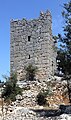
Tower from the southwest

Entrance in the southeast

Olbic characters

Building remains


The remains of the ancient, probably Roman settlement Kurşun Kalesi were discovered in the local area in 2007 . It is located on a hill, measures about 200 × 300 meters and consists of residential houses as well as a stoa and a temple at the highest point .
Web links
Individual evidence
- ↑ nufusu.com
- ^ Website Silifke
- ↑ Turkish Institute for Statistics ( Memento from September 21, 2013 in the Internet Archive )
- ↑ Serra Durugönül : Towers and Settlements in Rough Cilicia. Asia Minor Studies Volume 28. Rudolf Habelt, Bonn 1998 ISBN 3-7749-2840-1 pp. 1, 92, 121, plate 58 fig. 3–4.
- ↑ Hamdi Şahin, Aşkım Özdizbay: Dağlık Kilikia Kurşun Kalesi Tapınağı ve Stoasına İlişkin Yeni Öneriler In: Adalya XVII 2014 pp. 85–121