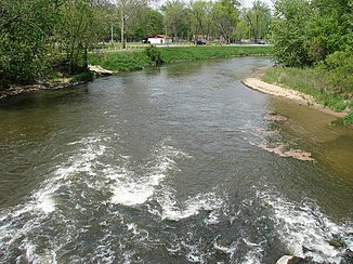
Yellow River (Kankakee River)
| Yellow River | ||
|
Yellow River below Knox |
||
| Data | ||
| Water code | US : 452845 | |
| location | Indiana (USA) | |
| River system | Mississippi River | |
| Drain over | Kankakee River → Illinois River → Mississippi River → Gulf of Mexico | |
| source | 5 km north of Bremen in St. Joseph County 41 ° 29 ′ 54 ″ N , 86 ° 9 ′ 8 ″ W |
|
| Source height | 245 m | |
| muzzle |
Kankakee River Coordinates: 41 ° 16 ′ 16 " N , 86 ° 49 ′ 35" W 41 ° 16 ′ 16 " N , 86 ° 49 ′ 35" W. |
|
| Mouth height | 202 m | |
| Height difference | 43 m | |
| Bottom slope | approx. 0.27 ‰ | |
| length | approx. 160 km | |
| Catchment area | approx. 1140 km² | |
| Discharge at Plymouth A Eo gauge : 761 km² |
MQ 1949/2015 Mq 1949/2015 |
7.8 m³ / s 10.2 l / (s km²) |
| Discharge at the Knox A Eo gauge : 1127 km² Location: 18 km above the mouth |
MQ 1944/2015 Mq 1944/2015 |
11.8 m³ / s 10.5 l / (s km²) |
| Small towns | Bremen , Knox , Plymouth | |
The Yellow River is a left tributary of the Kankakee River in the US state of Indiana . It has a length of about 160 km and drains an area of about 1140 km². The mean discharge at Knox, 18 km above the estuary, is 11.8 m³ / s.
course
The Yellow River rises 3 miles north of Bremen in St. Joseph County in northern Indiana. It initially flows about 20 km south and passes the western outskirts of Bremen. The Yellow River then turns west. It flows through the small town of Plymouth and flows again a short distance to the south before turning west again. Less than 20 km from its confluence with the Kankakee River, the river passes the northern outskirts of Knox . The river is channeled for the last 17 kilometers to the mouth.
nature and environment
The 8.5 km stretch of river between the bridge on Indiana State Road 39 and the estuary is in the Kankakee Fish & Wildlife Area . The area comprises a swampy area with alluvial forests and fields that are usually flooded during floods.
