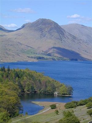
Yewbarrow
| Yewbarrow | ||
|---|---|---|
|
Yewbarrow seen across Wast Water |
||
| height | 627 m ASL | |
| location | Cumbria , England | |
| Mountains | Cumbrian Mountains | |
| Coordinates | 54 ° 27 '56 " N , 3 ° 16' 35" W | |
|
|
||
| Type | Wainwright | |
The Yewbarrow is a mountain in the Lake District , Cumbria , England . The Yewbarrow is located in Wasdale at the northwest end of Wast Water . The Yewbarrow is located west of the hamlet Wasdale Head and rises 627 m high directly from the Wast Water Lake, to which it drops steeply, as well as to the east and west. To the north, the Yewbarrow on Stirrup Crag is connected to the Red Pike via a ridge .
The Mosedale Beck and the Lingmell Beck flow on the east side of the Yewbarrow. The Over Beck flows on the west side of the mountain.
Due to the steep flanks, climbing the Yewbarrow is difficult. There is a route directly from Wast Water, the alternative is to get to the summit along the Over Beck and then over the Stirrup Crag. The Yewbarrow can be used as the start or end point of the Mosedale Horseshoe, a circular hiking trail that leads over Red Pike, Scoat Fell and Pillar around one of the Wasdale's side valleys.
swell
- Alfred Wainwright : A Pictorial Guide to the Lakeland Fells, Vol. 7 The Western Fells , Frances Lincoln, 2nd revised edition, 2009, ISBN 978-0711221994 .

