
Zacatlán
| Zacatlán | ||
|---|---|---|
|
Coordinates: 19 ° 56 ′ N , 97 ° 58 ′ W Zacatlán on the map of Puebla
|
||
| Basic data | ||
| Country | Mexico | |
| State | Puebla | |
| Municipio | Zacatlán | |
| Residents | 33,736 (2010) | |
| City insignia | ||
 |
||
| Detailed data | ||
| surface | 15.1 km 2 | |
| Population density | 2.234 inhabitants / km 2 | |
| height | 2000 m | |
| Website | ||
 |
||
 |
||
 |
||

Zacatlán is a city with about 40,000 inhabitants and the capital of the approximately 90,000 inhabitants of the municipality of the same name (municipio) in the northwest of the Mexican state of Puebla . Because of its colonial center, the city is one of the Pueblos Mágicos .
Location and climate
The city of Zacatlán is located in the Mexican highlands about 175 km (driving distance) northeast of the city of Puebla at an altitude of about 2000 m ; Mexico City is approximately 215 km to the southwest. The climate is temperate to mild; The rain, which is abundant by Mexican standards (approx. 1080 mm / year), comes from the Atlantic or the Gulf of Mexico and falls mainly during the summer half-year.
population
| year | 1950 | 1980 | 2000 | 2005 | 2010 |
| Residents | 4,680 | 11,970 | 28,773 | 30,805 | 33,736 |
Only a small part of the population is of Spanish descent; Colloquial languages are Spanish and a regional Nahuatl dialect.
economy
The inhabitants of the area live from agriculture, which also includes fruit growing (especially apples, plums and cherries) and livestock farming. Small traders, craftsmen and service providers of all kinds have settled in the city itself.
history
In 1115 the area came under the control of the Chichimecs ; later other Nahuatl-speaking tribes followed. The Aztecs came in the 14th century, and their empire was conquered between 1519 and 1521 by the Spanish conquistadors under Hernán Cortés . The area around Zacatlán was handed over to Hernán López de Avila. The present city did not come into being until 1562. The Franciscan Order founded a convent here with the aim of proselytizing the Indians, which in 1661 was placed under secular priests. In the struggle for the independence of Mexico (1810-1821), the large landowner José Francisco Osorno, who controlled the area around Zacatlán for a long time, stood out. In 1847 Zacatlán received full city rights (ciudad) .
Attractions
- Particularly impressive is the right-angled network of streets in the colonial center of the city with its many historical buildings, which are mainly in the area of the Parque Central .
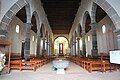
- The former Franciscan convent was built between 1562 and 1567. The church has three aisles and is spanned by a wooden beam ceiling.
- The two- tower church of San Pedro , built at the end of the 18th century in the classicist Baroque style , with its extensions stands directly on the Plaza Mayor ; the vaulted interior has a single nave, but has a transept with a domed crossing .
- The two-storey town hall (Palacio Municipal) was built between 1876 and 1896. The ground floor is opened by arcades (portales) .
- The city has a clock museum .

Parish Church of San Pedro

Parish Church of San Pedro

San Francisco de Asis Church
San Francisco de Asis Church


_2.jpg)

- Surroundings
- Approx. 11 km south of the city are the up to 350 m high Tulimán waterfalls (cascadas) .
- Approx. 15 km northwest of Zacatlán is the Valle de las Piedras Encimadas ("Valley of the stones lying on top of each other") with its sometimes bizarre rock formations.
Web links
- Zacatlán - Maps, photos and information (INAFED, Spanish)
- Zacatlán - Photos and information (Spanish)
- Zacatlán, sights - photos and information (Spanish)