
Zeitzgrund

As Zeitzgrund refers to the landscape protection - and recreation area of Zeitz creek between Hermsdorf and Stadtroda . The wooded area belongs to the Thuringian woodland and has a number of sights, such as
- the pitch furnace model - The demonstration model was built on the remains of a find from an old pitch furnace. It was a medieval plant for the production of tar and pitch , besides the charcoal burner it was a typical timber agricultural trade.
- the nature trail , today named after the teacher Georg Bocklisch (1924-2007) in "Lehrer-Bocklisch-Weg". Georg Bocklisch originally laid out the nature trail in Zeitzgrund according to his ideas, together with voluntary student work groups over five years of intensive work.
- the Teufelstalbrücke with the Teufelstal
- the Hasental as a connection between the Teufelstal and the village of Schleifreisen
- the large and small Rabsburg, both so-called "Raubburgen" in a deserted place from the 13th century, whereby large parts of the large Rabsburg were destroyed by the construction of the Weimar – Gera railway in 1873.
- the former family crypt of the Lauer family of paper manufacturers in Rabsberg
Along the deeply cut Zeitzbach valley, the well-developed main hiking trail, which often runs on the side of the Zeitzbach, extends, on which there are several mills, some of which are now run as restaurants:
- Bockmühle (since 1351, formerly a rest home, now used again as a guesthouse and pub)
- Ziegenmühle (since 1720, today restaurant with its own brewery)
- Janismühle (since 1494, today riding stables, guesthouse and restaurant with beer garden)
- Paper mill (since 1664, unused for many years, today under reconstruction)
- Neumühle (since 1766, today unused and left to decay)
- Fulling mill (since 1672, today used for agriculture)

Zeitzbach

Ruin in the Zeitzgrund
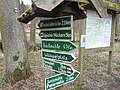
Signpost in Zeitzgrund
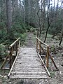
A section on the Lehrer-Bocklisch-Weg
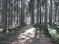
On the Köhlerberg on the Lehrer-Bocklisch-Weg
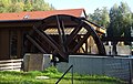
Janismill
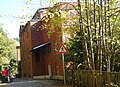
Janismill

Tunnel at the paper mill under the Weimar – Gera railway line

A 4 motorway bridge over the Zeitzgrund


Web links
Commons : Zeitzgrund - collection of images, videos and audio files
- Holzland hike on geraer-wanderverein.de
- The Zeitzgrund and its mills
- The Zeitzgrund - excursion destination between Hermsdorf and Stadtroda
Coordinates: 50 ° 53 ′ 14 " N , 11 ° 48 ′ 38" E