Central Greece
|
Στερεά / Κεντρική Ελλάδα mainland / Central Greece |
|
|---|---|

|
|
| Basic data | |
| State : | Greece |
| Administrative regions : |
Attica Central Greece West Greece |
| Surface: | 24,818.3 km² |
| Residents: | 4,591,568 (2001 ) |
| Population density: | 185 inhabitants per km² |
| FIPS code | GR-STE |
| Website : | stereaellada.gr |
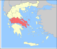
Central Greece ( Greek Κεντρική Ελλάδα Kendrikí Elláda ) or mainland Greece ( Greek Στερεά Ελλάδα Central Greece ) is a historical region in Greece and by the state as a geographical region '(today Greek γεογραφικό διαμέρισμα geografiko diamerisma out). It encompasses the area of mainland Greece, which belonged to the national territory immediately after Greece gained independence (with the exception of the Peloponnese peninsula and including the island of Evia and the islands of the prefecture of Piraeus ) and is usually literally referred to in Greek as "mainland Greece" ( Greek Στερεά Ελλάδα Sterea Ellada , or in Greek Χέρσος Ελλάς Chersos Ellas ). Another name for the landscape is Roumeli ( Greek Ρούμελη ), derived from the Turkish term Vilayet Rumeli for the southern Balkans, German Rumelien , meaning land of the Romioi ("land of the (Eastern) Romans", i.e. the Greeks ).
Landscape includes:
- from the region of Western Greece the Aetolia-Acarnania regional unit
- the Attica region
- the Central Greece region with the regional districts
location
The landscape borders in the north on Epirus and Thessaly , in the south on the Peloponnese peninsula , in the west on the Ionian Sea and the Gulf of Corinth and in the east on the Aegean Sea .
Statistical region
As a statistical region (NUTS-1) , Central Greece comprises the regions:
- Epirus
- Ionian islands
- West Greece
- Central Greece and
- Peloponnese
The Attica region forms its own statistical unit.
Individual evidence
- ↑ Central Greece with the regional districts: Boeotia , Euboea , Evrytania , Fokida and Fthiotida .
- ^ From the region of western Greece, the regional district of Aetolia-Acarnania .
- ↑ 2001 Census, statistics.gr ( Memento from April 18, 2009 in the Internet Archive ) (PDF; 875 kB) National Statistical Service of Greece (ΕΣΥΕ)
